IMAGES TAKEN NEAR TO
Victoria Road, PONTYPOOL, NP4 8PT
Introduction
This page details the photographs taken nearby to Victoria Road, NP4 8PT by members of the Geograph project.
The Geograph project started in 2005 with the aim of publishing, organising and preserving representative images for every square kilometre of Great Britain, Ireland and the Isle of Man.

There are currently over 7.5m images from over14,400 individuals and you can help contribute to the project by visiting https://www.geograph.org.uk
Image Map
Images are licensed for reuse under creativecommons.org/licenses/by-sa/2.0
Notes
- Clicking on the map will re-center to the selected point.
- The higher the marker number, the further away the image location is from the centre of the postcode.
Image Listing (62 Images Found)
Images are licensed for reuse under creativecommons.org/licenses/by-sa/2.0
Image
Details
Distance
1
Rising Sun Inn, Abersychan
Pub on Cwmavon Road (A4043). A notice shows "Open all day. Open for food 12.00-2.30 6.30-9.30"
Image: © Jaggery
Taken: 28 Apr 2011
0.00 miles
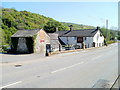
3
Victoria Village Community Hall, Abersychan
Located on the east side of Cwmavon Road (A4043). Victoria Village is a small hamlet within Abersychan.
Image: © Jaggery
Taken: 28 Apr 2011
0.06 miles
4
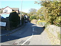
Victoria Road, Abersychan
Victoria Road heads north away from Lower Harper's Road towards Ffrwd Cottages.
On the street sign, the Welsh equivalent of Victoria is Buddug, which is also Welsh for Boadicea or Boudica.
Image: © Jaggery
Taken: 25 Oct 2010
0.06 miles
5
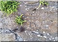
Ordnance Survey Cut Mark
This OS cut mark can be found on the wall at the junction of Harpers Road and Viaduct Road. It marks a point 220.273m above mean sea level.
Image: © Adrian Dust
Taken: 25 Aug 2019
0.07 miles
6
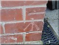
Ordnance Survey Cut Mark
This OS cut mark can be found on No25 Harpers Road. It marks a point 213.473m above mean sea level.
Image: © Adrian Dust
Taken: 25 Aug 2019
0.07 miles
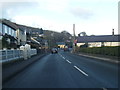
7
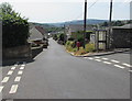
South along Harper's Road from Garndiffaith towards Abersychan
Looking past the Lower Stoney Road junction on the left and the Stoney Road junction on the right.
Image: © Jaggery
Taken: 19 Jul 2018
0.09 miles
8
Dave's Bodyshop, Abersychan
Car body repair and paint specialists located on the east side of Cwmavon Road (A4043).
Image: © Jaggery
Taken: 28 Apr 2011
0.09 miles
9
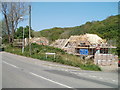
New houses, Abersychan
Houses are being built on a site at the corner of Cwmavon Road (A4043) and Waterworks Lane.
Image: © Jaggery
Taken: 28 Apr 2011
0.09 miles
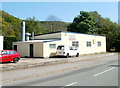
10
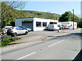
Cwmffrwd Service Station, Abersychan
Located on Cwmavon Road (A4043), viewed from the turning for Waterworks Lane.
Image: © Jaggery
Taken: 28 Apr 2011
0.09 miles