1
Padlocked kissing gate blocking entry to a riverside track, Pontnewynydd
Access to a track along the east bank of the Afon Lwyd is prevented by a padlocked kissing gate alongside a footbridge http://www.geograph.org.uk/photo/2424970 over the river.
Image: © Jaggery
Taken: 10 May 2011
0.03 miles
2
Approach to bridge over Afon Lwyd
Community Link cycle and pedestrian path from Pontnewynydd Park. The kissing gate leads to a thicket of brambles!
Image: © M J Roscoe
Taken: 19 Nov 2020
0.04 miles
3
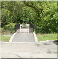
Bridge over Afon Lwyd, Fairview Court
Community Link cycle and pedestrian path to Pontnewynydd Park. The sign was not present in 2011
Image
Image: © M J Roscoe
Taken: 19 Nov 2020
0.04 miles
4
Afon Lwyd above footbridge, Fairview Court
Looking upstream from cycle and pedestrian path.
Image: © M J Roscoe
Taken: 19 Nov 2020
0.04 miles
5
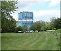
Renovated Fairview Court, Pontnewynydd
The 12-storey block of 70 flats was built in the 1960s. Viewed across George Street.
This view was taken in September 2011, shortly after the block was renovated. http://www.geograph.org.uk/photo/2424940
Here's a view http://www.geograph.org.uk/photo/2127859 of Fairview Court in October 2010.
Image: © Jaggery
Taken: 23 Sep 2011
0.04 miles
6
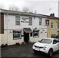
The Pegasus, Pontnewynydd
Hill Street pub below the A4043 Osborne Road. Formerly the Masons Arms.
http://www.geograph.org.uk/photo/4766924 to a closer view of the name sign.
Image: © Jaggery
Taken: 17 Dec 2015
0.05 miles
7
Fairview Court, Pontnewynydd
12-storey block of 70 flats, built in the 1960s. Viewed across George Street.
UPDATE
This view http://www.geograph.org.uk/photo/3369530 taken in September 2011 shows the block after renovation.
Image: © Jaggery
Taken: 25 Oct 2010
0.05 miles
8
Renovation work, Fairview Court, Pontnewynydd
Blue sheeting covers Fairview Court, a 12-storey block of 70 flats, during a £1 million renovation and improvement project. The block, located between George Street and the Afon Lwyd river, looked like this http://www.geograph.org.uk/photo/2127859 in October 2010.
When work is completed, there will be many changes, including the installation of wind turbines and solar panels. Money earned from selling electricity to the National Grid will help pay for the work. Other improvements include a single storey extension on the roof to create a residents’ sky lounge and IT suite with glass walls. Flats that needed internal work are being refurbished with a new kitchen, bathroom and electrical rewiring.
Image: © Jaggery
Taken: 10 May 2011
0.05 miles
9
Afon Lwyd river viewed from near Fairview Court, Pontnewynydd
Viewed from a footbridge over the river about 30 metres north of Fairview Court. http://www.geograph.org.uk/photo/2424940
Image: © Jaggery
Taken: 10 May 2011
0.05 miles
10
Footbridge over the Afon Lwyd, Pontnewynydd
The footbridge across the river http://www.geograph.org.uk/photo/2424952 connects Fairview Court http://www.geograph.org.uk/photo/2424940 on this side with a recreation area.
Image: © Jaggery
Taken: 10 May 2011
0.05 miles


