IMAGES TAKEN NEAR TO
George Street, PONTYPOOL, NP4 8NU
Introduction
This page details the photographs taken nearby to George Street, NP4 8NU by members of the Geograph project.
The Geograph project started in 2005 with the aim of publishing, organising and preserving representative images for every square kilometre of Great Britain, Ireland and the Isle of Man.

There are currently over 7.5m images from over14,400 individuals and you can help contribute to the project by visiting https://www.geograph.org.uk
Image Map
Images are licensed for reuse under creativecommons.org/licenses/by-sa/2.0
Notes
- Clicking on the map will re-center to the selected point.
- The higher the marker number, the further away the image location is from the centre of the postcode.
Image Listing (200 Images Found)
Images are licensed for reuse under creativecommons.org/licenses/by-sa/2.0
Image
Details
Distance
1
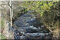
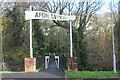
Afon Lwyd above footbridge, Fairview Court
Looking upstream from cycle and pedestrian path.
Image: © M J Roscoe
Taken: 19 Nov 2020
0.02 miles
2
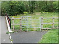
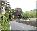
Padlocked kissing gate blocking entry to a riverside track, Pontnewynydd
Access to a track along the east bank of the Afon Lwyd is prevented by a padlocked kissing gate alongside a footbridge http://www.geograph.org.uk/photo/2424970 over the river.
Image: © Jaggery
Taken: 10 May 2011
0.02 miles
4
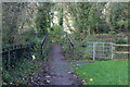
Approach to bridge over Afon Lwyd
Community Link cycle and pedestrian path from Pontnewynydd Park. The kissing gate leads to a thicket of brambles!
Image: © M J Roscoe
Taken: 19 Nov 2020
0.04 miles
5
Bridge over Afon Lwyd, Fairview Court
Community Link cycle and pedestrian path to Pontnewynydd Park. The sign was not present in 2011 Image
Image: © M J Roscoe
Taken: 19 Nov 2020
0.04 miles
6
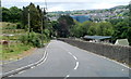
Hospital Road Pontnewynydd
Hospital Road descends from the junction http://www.geograph.org.uk/photo/2412304 with Leigh Road and Lower Leigh Road.
Image: © Jaggery
Taken: 9 May 2011
0.04 miles
7
Potential hazard ahead for walkers on Hospital Road, Pontnewynydd
I obviously lived to tell the tale, but as a walker felt distinctly uncomfortable at the prospect ahead - no pavements and a double bend in the road. And there was no comfort in the name of the road - there is no hospital in the vicinity.
Image: © Jaggery
Taken: 9 May 2011
0.04 miles
8
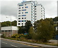
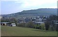
Renovated Fairview Court, Pontnewynydd
The 12-storey block of 70 flats was built in the 1960s. Viewed across George Street.
This view was taken in September 2011, shortly after the block was renovated. http://www.geograph.org.uk/photo/2424940
Here's a view http://www.geograph.org.uk/photo/2127859 of Fairview Court in October 2010.
Image: © Jaggery
Taken: 23 Sep 2011
0.07 miles
9
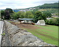
Ty-gwyn Farm, Pontnewynydd
Farm buildings viewed across the Hospital Road perimeter wall.
Image: © Jaggery
Taken: 9 May 2011
0.07 miles
10
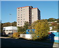
Fairview Court, Pontnewynydd
12-storey block of 70 flats, built in the 1960s. Viewed across George Street.
UPDATE
This view http://www.geograph.org.uk/photo/3369530 taken in September 2011 shows the block after renovation.
Image: © Jaggery
Taken: 25 Oct 2010
0.08 miles