1
The Afon Lwyd Valley
Image: © Roger Cornfoot
Taken: 11 Apr 2007
0.00 miles
2
Hospital Road Pontnewynydd
Hospital Road descends from the junction http://www.geograph.org.uk/photo/2412304 with Leigh Road and Lower Leigh Road.
Image: © Jaggery
Taken: 9 May 2011
0.03 miles
3
Potential hazard ahead for walkers on Hospital Road, Pontnewynydd
I obviously lived to tell the tale, but as a walker felt distinctly uncomfortable at the prospect ahead - no pavements and a double bend in the road. And there was no comfort in the name of the road - there is no hospital in the vicinity.
Image: © Jaggery
Taken: 9 May 2011
0.03 miles
4
Ty-gwyn Farm, Pontnewynydd
Farm buildings viewed across the Hospital Road perimeter wall.
Image: © Jaggery
Taken: 9 May 2011
0.04 miles
5
Afon Lwyd above footbridge, Fairview Court
Looking upstream from cycle and pedestrian path.
Image: © M J Roscoe
Taken: 19 Nov 2020
0.04 miles
6
Padlocked kissing gate blocking entry to a riverside track, Pontnewynydd
Access to a track along the east bank of the Afon Lwyd is prevented by a padlocked kissing gate alongside a footbridge http://www.geograph.org.uk/photo/2424970 over the river.
Image: © Jaggery
Taken: 10 May 2011
0.05 miles
7
Approach to bridge over Afon Lwyd
Community Link cycle and pedestrian path from Pontnewynydd Park. The kissing gate leads to a thicket of brambles!
Image: © M J Roscoe
Taken: 19 Nov 2020
0.06 miles
8
Bridge over Afon Lwyd, Fairview Court
Community Link cycle and pedestrian path to Pontnewynydd Park. The sign was not present in 2011
Image
Image: © M J Roscoe
Taken: 19 Nov 2020
0.06 miles
9
Royal Oak, Pontnewynydd
Pub alongside the B4246. Some maps show this location as the southern end of Freeholdland Road
whereas the pub's website states (the northern end of) George Street.
Image: © Jaggery
Taken: 17 Dec 2015
0.09 miles
10
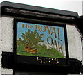
Royal Oak name sign, Pontnewynydd
On a corner of this http://www.geograph.org.uk/photo/4767230 pub. The faded gold lettering at the bottom of the sign formerly showed USHERS.
Image: © Jaggery
Taken: 17 Dec 2015
0.09 miles


