IMAGES TAKEN NEAR TO
Hospital Road, PONTYPOOL, NP4 8LE
Introduction
This page details the photographs taken nearby to Hospital Road, NP4 8LE by members of the Geograph project.
The Geograph project started in 2005 with the aim of publishing, organising and preserving representative images for every square kilometre of Great Britain, Ireland and the Isle of Man.

There are currently over 7.5m images from over14,400 individuals and you can help contribute to the project by visiting https://www.geograph.org.uk
Image Map
Images are licensed for reuse under creativecommons.org/licenses/by-sa/2.0
Notes
- Clicking on the map will re-center to the selected point.
- The higher the marker number, the further away the image location is from the centre of the postcode.
Image Listing (175 Images Found)
Images are licensed for reuse under creativecommons.org/licenses/by-sa/2.0
Image
Details
Distance
1
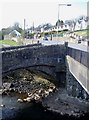
Bridges across the Afon Lwyd
At Hospital Road, Pontnewynydd.
Image: © Roger Cornfoot
Taken: 11 Apr 2007
0.02 miles
2
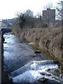
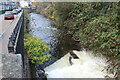
Weir, on the Afon Lwyd, Pontnewynydd
Image: © Roger Cornfoot
Taken: 11 Apr 2007
0.04 miles
3
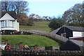
Leigh Road above Hospital Road, Pontnewynydd
Looking up from Pontnewynydd Park across Hospital Road to Leigh Road, with part of Pontnewynydd Social Club on the right.
Image: © M J Roscoe
Taken: 19 Nov 2020
0.04 miles
4

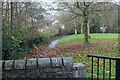
Entrance to Pontnewydd Park
Community Links cycle and pedestrian path from Hospital Road into riverside park. At one time in the last century there was a swimming bath in the park. The white building beyond is Fairview Court.
Image: © M J Roscoe
Taken: 19 Nov 2020
0.05 miles
5
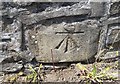
Ordnance Survey Cut Mark
This OS cut mark can be found on the west parapet of Pont Newynydd. It marks a point 138.395m above mean sea level.
Image: © Adrian Dust
Taken: 7 Jul 2019
0.05 miles
6
Afon Lwyd by Mill Road, Pontnewynydd
Looking upstream across small weir.
Image: © M J Roscoe
Taken: 19 Nov 2020
0.05 miles
7
Riverside path, Pontnewynydd Park, Pontypool
The river, the Afon Lwyd, is to the left of the overgrown railings.
Image: © M J Roscoe
Taken: 19 Nov 2020
0.05 miles
8
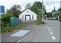
St John Ambulance building, Pontnewynydd, Pontypool
Located on the west side of Hospital Road, opposite a row of bungalows. http://www.geograph.org.uk/photo/2422831
St John Ambulance, founded in 1877, provides ambulance services and the teaching of, and practice in, medical first aid.
Image: © Jaggery
Taken: 10 May 2011
0.06 miles
9
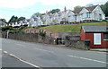
Elevated bungalows, Hospital Road, Pontnewynydd, Pontypool
Based several metres above street level, the bungalows face a St John Ambulance building. http://www.geograph.org.uk/photo/2422820
Image: © Jaggery
Taken: 10 May 2011
0.06 miles
10
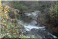
Afon Lwyd below Hospital Road Bridge, Pontnewynydd
Looking downstream after much rain.
Image: © M J Roscoe
Taken: 19 Nov 2020
0.06 miles