IMAGES TAKEN NEAR TO
Penygarn Road, PONTYPOOL, NP4 8JA
Introduction
This page details the photographs taken nearby to Penygarn Road, NP4 8JA by members of the Geograph project.
The Geograph project started in 2005 with the aim of publishing, organising and preserving representative images for every square kilometre of Great Britain, Ireland and the Isle of Man.

There are currently over 7.5m images from over14,400 individuals and you can help contribute to the project by visiting https://www.geograph.org.uk
Image Map
Images are licensed for reuse under creativecommons.org/licenses/by-sa/2.0
Notes
- Clicking on the map will re-center to the selected point.
- The higher the marker number, the further away the image location is from the centre of the postcode.
Image Listing (74 Images Found)
Images are licensed for reuse under creativecommons.org/licenses/by-sa/2.0
Image
Details
Distance
3
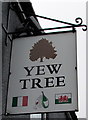
Yew Tree name sign near Trevethin
Depicting the flag of Italy and the flag of Wales, the sign hangs from a wall bracket here. http://www.geograph.org.uk/photo/5218760
Image: © Jaggery
Taken: 5 Dec 2016
0.02 miles
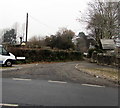
4
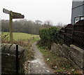
Wooden signpost alongside Penygarn Road near Trevethin
The Community Link signpost points the way to Pontypool, Trevethin and St Cadocs.
Image: © Jaggery
Taken: 5 Dec 2016
0.03 miles
5
Folly Lane, Trevethin
From Penygarn Road along Folly Lane towards Folly Road.
Image: © Jaggery
Taken: 5 Dec 2016
0.03 miles
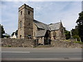
6
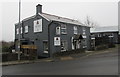
Yew Tree Italian restaurant south of Trevethin
Viewed across Penygarn Road in December 2016.
The building has had a makeover since this http://www.geograph.org.uk/photo/2431149 May 2011 photo.
Image: © Jaggery
Taken: 5 Dec 2016
0.03 miles
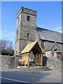
7
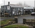
Yew Tree and the Coffee Shop near Trevethin
Viewed across Penygarn Road from St Cadoc's churchyard. The main building is
Yew Tree Italian restaurant. Its Coffee Shop is in the smaller building on the right.
Image: © Jaggery
Taken: 5 Dec 2016
0.03 miles
8
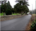
Penygarn Road towards Penygarn
South of Trevethin, Penygarn Road passes the perimeter wall of St Cadoc's churchyard.
Image: © Jaggery
Taken: 5 Dec 2016
0.04 miles
9
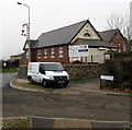
Trevethin Church Hall
Viewed across Folly Lane. The left half of the nameboard shows TREVETHIN CHURCH HALL.
The right half shows TRAC2 The Really Amazing Charity. A TRAC2 van is parked outside the hall.
Image: © Jaggery
Taken: 5 Dec 2016
0.05 miles
10
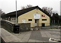
Trevethin and Penygarn Community Centre, Trevethin
Located below the south side of Folly Road, near Trevethin & Penygarn Sports & Social Club. http://www.geograph.org.uk/photo/5227963
Image: © Jaggery
Taken: 5 Dec 2016
0.05 miles