IMAGES TAKEN NEAR TO
Newman Road, PONTYPOOL, NP4 8HE
Introduction
This page details the photographs taken nearby to Newman Road, NP4 8HE by members of the Geograph project.
The Geograph project started in 2005 with the aim of publishing, organising and preserving representative images for every square kilometre of Great Britain, Ireland and the Isle of Man.

There are currently over 7.5m images from over14,400 individuals and you can help contribute to the project by visiting https://www.geograph.org.uk
Image Map
Images are licensed for reuse under creativecommons.org/licenses/by-sa/2.0
Notes
- Clicking on the map will re-center to the selected point.
- The higher the marker number, the further away the image location is from the centre of the postcode.
Image Listing (71 Images Found)
Images are licensed for reuse under creativecommons.org/licenses/by-sa/2.0
Image
Details
Distance
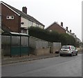
1
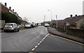
Newman Road, Trevethin
Viewed from the corner of Beeches Road. Trevethin is on hilly ground in the north of Pontypool.
Here, the houses on the left (east) side of the road are set a couple of metres higher than the houses on the right.
Image: © Jaggery
Taken: 5 Dec 2016
0.05 miles
2
Rooftop solar panels, Upland Drive, Trevethin
Viewed in December 2016. There were no panels here in a May 2011 Google Earth Street View.
Image: © Jaggery
Taken: 5 Dec 2016
0.05 miles
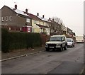
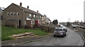
3
Row of houses above Upland Drive, Trevethin
Houses on this side of Upland Drive are set slightly above road level.
Image: © Jaggery
Taken: 5 Dec 2016
0.05 miles
4
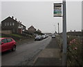
Upland Drive bus stop, Trevethin
In December 2016 this stop is on Stagecoach bus route 15.
Image: © Jaggery
Taken: 5 Dec 2016
0.07 miles
5
Newman Road bus shelter, Trevethin
Opposite the Beeches Road junction.
Image: © Jaggery
Taken: 5 Dec 2016
0.07 miles
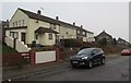
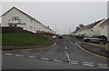
6
Upland Drive, Trevethin
This part of Upland Drive is near the Beeches Road junction behind the camera.
Image: © Jaggery
Taken: 5 Dec 2016
0.08 miles
7
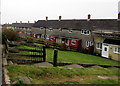
Steps down to Upland Drive houses, Trevethin
Houses on this side of Upland Drive are below road level
whereas those on the opposite side http://www.geograph.org.uk/photo/5296513 are above road level.
Image: © Jaggery
Taken: 5 Dec 2016
0.08 miles
8
Canford Close, Trevethin
Cul-de-sac on the southeast side of Glen View Road.
Image: © Jaggery
Taken: 5 Dec 2016
0.08 miles
9
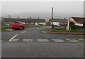
Junction of Newman Road and Beeches Road, Trevethin
Beeches Road descends from Newman Road.
The bilingual sign on the right shows that Beeches Road is Heol Ffawydd in Welsh.
Image: © Jaggery
Taken: 5 Dec 2016
0.08 miles
10
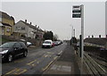
Upland Drive bus stop, Trevethin
In December 2016 this stop is on Stagecoach bus route 15.
Image: © Jaggery
Taken: 5 Dec 2016
0.09 miles