IMAGES TAKEN NEAR TO
Old Bailey, PONTYPOOL, NP4 8EU
Introduction
This page details the photographs taken nearby to Old Bailey, NP4 8EU by members of the Geograph project.
The Geograph project started in 2005 with the aim of publishing, organising and preserving representative images for every square kilometre of Great Britain, Ireland and the Isle of Man.

There are currently over 7.5m images from over14,400 individuals and you can help contribute to the project by visiting https://www.geograph.org.uk
Image Map
Images are licensed for reuse under creativecommons.org/licenses/by-sa/2.0
Notes
- Clicking on the map will re-center to the selected point.
- The higher the marker number, the further away the image location is from the centre of the postcode.
Image Listing (137 Images Found)
Images are licensed for reuse under creativecommons.org/licenses/by-sa/2.0
Image
Details
Distance
1
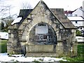
Pontypool horse drinking trough
Old drinking trough.
Image: © RAY JONES
Taken: 2 Mar 2006
0.01 miles
2
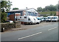
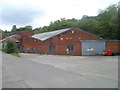
Rockhill Road premises of Autoservice (Pontypool) Ltd
A dealer for LDV Group Ltd, the business has a stock of new and used commercial vehicles for sale, and a wide range of vehicle parts. The business also does MOT class 4/5 and 7 tests.
On the left is the edge of the bridge carrying Usk Road over the Afon Lwyd river.
Image: © Jaggery
Taken: 7 Jun 2011
0.01 miles
3
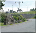
Victorian lamppost and memorial fountain, Pontypool
Located on Fountain Road. The faded inscription in stone on the fountain is
"This fountain was erected by neighbours and friends in memory of Elizabeth Catherine, wife of Alfred Addams Williams, of Maesderwen, whose estimable qualities and godly life are worthy alike of remembrance and imitation.
AD1889 (very faded - could be 1886 or 1888)
The lamppost and fountain are no longer in use.
Image: © Jaggery
Taken: 1 Jul 2011
0.01 miles
4
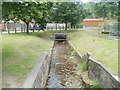
Nant Dar disappears from view, Pontypool
40 metres after emerging into daylight, http://www.geograph.org.uk/photo/2489106 the stream Nant Dar enters a culvert. A few tens of metres further ahead, it flows into the Afon Lwyd.
Image: © Jaggery
Taken: 1 Jul 2011
0.01 miles
5
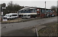
Service area, Autoservice (Pontypool) Ltd
The rear of the Rockhill Road premises http://www.geograph.org.uk/photo/2448424 contains the business's vehicle servicing and repairs section, locked up at the end of the work day a few minutes before this view was taken.
Image: © Jaggery
Taken: 1 Jul 2011
0.01 miles

7
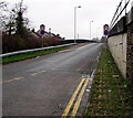
Entry slip road to the A472 from Rockhill Road, Pontypool
Signs show that the speed limit increases to 50mph and that the road ahead is a clearway.
The A472 here uses a former railway route.
Image: © Jaggery
Taken: 11 Apr 2018
0.02 miles
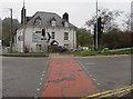
8
Auto Service, Pontypool
Garage on the corner of Rockhill Road and Fountain Road.
Image: © Jaggery
Taken: 11 Apr 2018
0.03 miles
9
Pelican crossing at the edge of Rockhill Road, Pontypool
One of several adjacent pelican crossings, this one is across the start of the entry slip road to the A472.
Chambers Dictionary states that pelican in this context is adapted from "pedestrian light controlled crossing".
Image: © Jaggery
Taken: 11 Apr 2018
0.04 miles
10
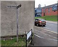
Wooden Community Link signpost on the corner of Fountain Road and Rockhill Road, Pontypool
The signpost shows that Pontymoile is Pont y Moel in Welsh.
Image: © Jaggery
Taken: 11 Apr 2018
0.04 miles