IMAGES TAKEN NEAR TO
Arcadia Way, PONTYPOOL, NP4 8DX
Introduction
This page details the photographs taken nearby to Arcadia Way, NP4 8DX by members of the Geograph project.
The Geograph project started in 2005 with the aim of publishing, organising and preserving representative images for every square kilometre of Great Britain, Ireland and the Isle of Man.

There are currently over 7.5m images from over14,400 individuals and you can help contribute to the project by visiting https://www.geograph.org.uk
Image Map
Images are licensed for reuse under creativecommons.org/licenses/by-sa/2.0
Notes
- Clicking on the map will re-center to the selected point.
- The higher the marker number, the further away the image location is from the centre of the postcode.
Image Listing (63 Images Found)
Images are licensed for reuse under creativecommons.org/licenses/by-sa/2.0
Image
Details
Distance
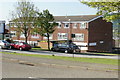
1
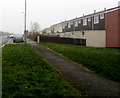
Woodside Road houses, Trevethin
From the corner of Glen View Road.
Image: © Jaggery
Taken: 5 Dec 2016
0.06 miles
3
Central Drive, Trevethin
From Glen View Road, Central Drive extends for 300 metres to Bythway Road.
Image: © Jaggery
Taken: 5 Dec 2016
0.08 miles
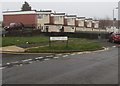
4
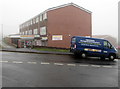
Glenview Stores, Trevethin
Convenience store on the corner of Glen View Road and Beechwood Walk, at the northwest edge of Trevethin.
Image: © Jaggery
Taken: 5 Dec 2016
0.09 miles
5
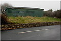
Dark green building near Woodside Road Allotments, Trevethin
Near the NW edge of a narrow strip of allotments extending for 200 metres alongside Woodside Road.
Image: © Jaggery
Taken: 5 Dec 2016
0.10 miles
6
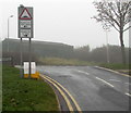
Humps warning sign facing Glen View Road, Trevethin
On the approach to Woodside Road, where there are humps across the road for 300 yards to the left and half a mile to the right. Viewed on a day of poor visibility caused by upland fog on December 5th 2016.
Image: © Jaggery
Taken: 5 Dec 2016
0.10 miles
7
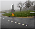
Yellow grit box, Glen View Road, Trevethin
At 275 metres (900 ft) above mean sea level, this northern part of Trevethin is one of the highest locations in Pontypool. Therefore the contents of the grit box are likely to be used to treat the road in icy or snowy conditions more often than in lower-lying areas.
Image: © Jaggery
Taken: 5 Dec 2016
0.10 miles
8
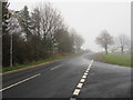
Woodside Road, Trevethin
A road at the northern edge of Trevethin, here about 275 metres (900 ft) above mean sea level.
Image: © Jaggery
Taken: 5 Dec 2016
0.10 miles
9
Trevethin Residents Organisation Office
The office is at the Glen View Road end of a block, next door to J. & J.A Grocers.
Image: © Jaggery
Taken: 12 May 2010
0.11 miles
10
Beechwood Walk, Trevethin
Beechwood Walk (Rhodfa Coed Ffawydd in Welsh) viewed across Glen View Road.
http://www.geograph.org.uk/photo/5217184 to a foggy view taken 20 minutes earlier.
Image: © Jaggery
Taken: 5 Dec 2016
0.11 miles