1
Church Wood houses, Pontypool
Houses at the far end of a cul-de-sac connecting with the west side of Park Road.
Image: © Jaggery
Taken: 27 May 2011
0.07 miles
2
Clos Afon Llwyd, Pontypool
Southern end of close showing the footpath to houses on the eastern side of the close. The river (= afon) is to the right just over the railings.
Image: © M J Roscoe
Taken: 28 Aug 2015
0.11 miles
3
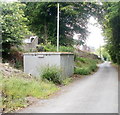
Gas box, Church Wood, Pontypool
The box is located on the side of Church Wood, http://www.geograph.org.uk/photo/2429706 a cul-de-sac on the west side of Park Road.
A notice on the road side of the box shows an 0800 phone number to ring before beginning any work on, or within 10 metres of, the box, or in an emergency.
Image: © Jaggery
Taken: 27 May 2011
0.11 miles
4
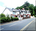
Four houses on a bend in Park Road, Pontypool
Just beyond the house at the far end, the road bends through 90 degrees.
Image: © Jaggery
Taken: 27 May 2011
0.11 miles
5
Afon Llwyd, Pontypool
Looking downstream from the southern end of Clos Afon Llwyd.
Image: © M J Roscoe
Taken: 28 Aug 2015
0.11 miles
6
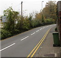
No parking on Park Road, Pontypool
Double yellow lines on both sides of the road make parking here illegal at any time.
Vegetation covers a part of the Welcome Penygarn sign.
Image: © Jaggery
Taken: 3 Nov 2015
0.12 miles
7
Penygarn Road houses at the Churchwood Close junction, Pontypool
Image: © Jaggery
Taken: 27 May 2011
0.12 miles
8
Churchwood Close, Pontypool
Houses at the eastern end of the close, viewed from Penygarn Road.
Image: © Jaggery
Taken: 27 May 2011
0.12 miles
9
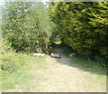
Track into woods from Riverside, Pontypool
Boulders block vehicular access to a track along the eastern bank of the Afon Lwyd, into woodland. Viewed from the edge of a road named Riverside.
Image: © Jaggery
Taken: 4 May 2011
0.12 miles
10
Afon Lwyd Close, Pontypool
Modern housing viewed across the main road, Riverside.
Image: © Jaggery
Taken: 4 May 2011
0.12 miles


