IMAGES TAKEN NEAR TO
Rockhill Road, PONTYPOOL, NP4 8AR
Introduction
This page details the photographs taken nearby to Rockhill Road, NP4 8AR by members of the Geograph project.
The Geograph project started in 2005 with the aim of publishing, organising and preserving representative images for every square kilometre of Great Britain, Ireland and the Isle of Man.

There are currently over 7.5m images from over14,400 individuals and you can help contribute to the project by visiting https://www.geograph.org.uk
Image Map
Images are licensed for reuse under creativecommons.org/licenses/by-sa/2.0
Notes
- Clicking on the map will re-center to the selected point.
- The higher the marker number, the further away the image location is from the centre of the postcode.
Image Listing (140 Images Found)
Images are licensed for reuse under creativecommons.org/licenses/by-sa/2.0
Image
Details
Distance
1
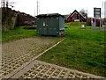
Pontymoile Gyratory electricity substation, Pontypool
The dark green Western Power Distribution electricity substation is on the south side of Rockhill Road.
Its identifier is PONTYMOILE GYRATORY S/S No. 531531.
Image: © Jaggery
Taken: 27 Jan 2015
0.02 miles
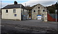
2
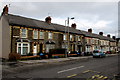
Rockhill Road houses, Pontypool
Clarence Road behind the camera becomes Rockhill Road ahead. The long row of houses, built c1900, is on the north side of Rockhill Road. There are no houses on the opposite side of the road, part of which is occupied by this http://www.geograph.org.uk/photo/2250514 church.
Image: © Jaggery
Taken: 27 Jan 2015
0.02 miles
3
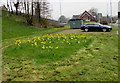
Rectangle of daffodils alongside Rockhill Road, Pontypool
On April 11th 2018 daffodils are in an unmown rectangle surrounded by mown grass.
Image: © Jaggery
Taken: 11 Apr 2018
0.03 miles
4
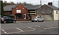
Top Dogs Grooming Service, Pontypool
Viewed across Rockhill Road.
Image: © Jaggery
Taken: 27 Jan 2015
0.03 miles
5
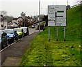
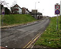
Directions sign alongside Rockhill Road, Pontypool
On the approach to the A472.
Image: © Jaggery
Taken: 11 Apr 2018
0.04 miles
6
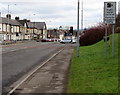
Traffic signal cameras sign, Rockhill Road, Pontypool
The sign resembles a speed camera sign. I don't recall seeing this wording elsewhere.
Image: © Jaggery
Taken: 27 Jan 2015
0.05 miles
7
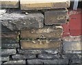
Ordnance Survey Cut Mark
This OS cut mark can be found on the wall of No13 Rockwell Road. It marks a point 123.779m above mean sea level.
Image: © Adrian Dust
Taken: 7 Jul 2019
0.05 miles
8
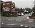
Old Foundry Yard, Rockhill Road, Pontypool
Premises of A.P.Waters Building Contractors Ltd on a bank of a river, the Afon Lwyd.
Image: © Jaggery
Taken: 11 Apr 2018
0.05 miles
9
Rockhill Road entrance to the Robert Price site in Pontypool
Builders merchants premises. Robert Price's address, The Old Foundry, shows what was here previously.
Image: © Jaggery
Taken: 27 Jan 2015
0.05 miles
10
Entrance slip road to the A472, Pontypool
From Rockhill Road, this is one of the motorway-style slip roads
to and from the A472, which here follows the route of a dismantled railway.
Image: © Jaggery
Taken: 27 Jan 2015
0.06 miles