IMAGES TAKEN NEAR TO
Usk Road, PONTYPOOL, NP4 8AA
Introduction
This page details the photographs taken nearby to Usk Road, NP4 8AA by members of the Geograph project.
The Geograph project started in 2005 with the aim of publishing, organising and preserving representative images for every square kilometre of Great Britain, Ireland and the Isle of Man.

There are currently over 7.5m images from over14,400 individuals and you can help contribute to the project by visiting https://www.geograph.org.uk
Image Map
Images are licensed for reuse under creativecommons.org/licenses/by-sa/2.0
Notes
- Clicking on the map will re-center to the selected point.
- The higher the marker number, the further away the image location is from the centre of the postcode.
Image Listing (40 Images Found)
Images are licensed for reuse under creativecommons.org/licenses/by-sa/2.0
Image
Details
Distance
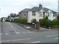
1
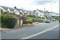
Usk Road bungalows, New Inn, Pontypool
Houses on the north side of New Inn, viewed from the edge of the road bridge http://www.geograph.org.uk/photo/2486975 over the Monmouthshire & Brecon canal.
Image: © Jaggery
Taken: 1 Jul 2011
0.01 miles
2
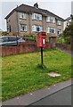
Queen Elizabeth II postbox on grass, New Inn, Pontypool
Alongside Usk Road.
Image: © Jaggery
Taken: 30 Apr 2023
0.02 miles
3

SE tip of Brecon Beacons National Park, New Inn, Pontypool
A plaque on the bridge carrying Usk Road across the Monmouthshire & Brecon canal shows Brecon Beacons National Park, marking its SE tip. My first thought was that it was an error as it seemed to be too far south. But no, maps confirm that a narrow, peninsula-like strip of the National Park, running south from the Blorenge, does indeed end here. The bridge is known as Jockey Bridge. http://www.geograph.org.uk/photo/1500152 Ahead are houses in New Inn.
Image: © Jaggery
Taken: 1 Jul 2011
0.05 miles
4
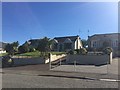
Usk Road
Housing on Usk Road, Pontypool.
Image: © Alan Hughes
Taken: 27 Sep 2018
0.05 miles
5
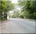
Usk Road reaches New Inn, Pontypool
After a long climb from the A4042 and Llanvihangel Pontymoel, Usk Road reaches the New Inn boundary sign. The stonework is part of a bridge carrying the road over the Monmouthshire & Brecon canal. Known as the Jockey Bridge, it is canal bridge number 55. http://www.geograph.org.uk/photo/1500152
Image: © Jaggery
Taken: 1 Jul 2011
0.08 miles
6
Usk Road
The road passes over the Monmouthshire and Brecon Canal.
Image: © Gordon Griffiths
Taken: 17 Sep 2011
0.09 miles
7
![Jockey Bridge [no 55] from the north](https://s2.geograph.org.uk/geophotos/03/66/95/3669582_41f14b28_120x120.jpg)
Jockey Bridge [no 55] from the north
Carrying the Usk Road over the Mon & Brec canal.
Image: © Christine Johnstone
Taken: 15 Sep 2013
0.09 miles
8
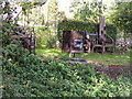
Macabre View
The Monmouthshire and Brecon Canal view at Pontypool.
Image: © Gordon Griffiths
Taken: 17 Sep 2011
0.10 miles
9
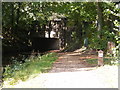
Pontypool Canal Bridge
The Monmouthshire and Brecon Canal passes under the Usk Road.
Image: © Gordon Griffiths
Taken: 17 Sep 2011
0.10 miles
10
Corner of Sunlea Crescent, New Inn, Pontypool
Sunlea Crescent heads away from Usk Road.
Image: © Jaggery
Taken: 1 Jul 2011
0.10 miles