IMAGES TAKEN NEAR TO
Acorn Close, PONTYPOOL, NP4 7UU
Introduction
This page details the photographs taken nearby to Acorn Close, NP4 7UU by members of the Geograph project.
The Geograph project started in 2005 with the aim of publishing, organising and preserving representative images for every square kilometre of Great Britain, Ireland and the Isle of Man.

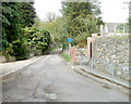
There are currently over 7.5m images from over14,400 individuals and you can help contribute to the project by visiting https://www.geograph.org.uk
Image Map
Images are licensed for reuse under creativecommons.org/licenses/by-sa/2.0
Notes
- Clicking on the map will re-center to the selected point.
- The higher the marker number, the further away the image location is from the centre of the postcode.
Image Listing (265 Images Found)
Images are licensed for reuse under creativecommons.org/licenses/by-sa/2.0
Image
Details
Distance
1
Upper section of Lock Up Lane, Abersychan
Lock Up Lane climbs towards the edge of woodland. The lower section http://www.geograph.org.uk/photo/2137773 was near the now demolished police station which opened in 1885.
Image: © Jaggery
Taken: 16 Apr 2011
0.04 miles
2
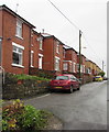
West side of North Road, Snatchwood, Abersychan
Houses on the west side of North Road, viewed from the Snatchwood Terrace end.
Image: © Jaggery
Taken: 17 Dec 2015
0.05 miles
3
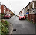
North Road, Snatchwood, Abersychan
Dead-end road viewed from the Snatchwood Terrace end.
Image: © Jaggery
Taken: 17 Dec 2015
0.05 miles
4
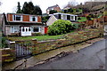
Lock Up Lane houses, Abersychan
On the south side of the lane above the A4043 Snatchwood Road.
Image: © Jaggery
Taken: 17 Dec 2015
0.07 miles
5
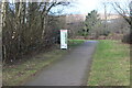
Cycle route information board at Pentwyn lane
Afon Lwyd Trail, NCR 492 on former railway, at exit to Pentwyn Lane; the railings, left, guard the underpass.
Image: © M J Roscoe
Taken: 25 Feb 2022
0.07 miles
7
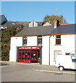
The Barber Shop, Abersychan
Located on the corner of Broad Street and Union Street, adjacent to a parking area.
Image: © Jaggery
Taken: 25 Oct 2010
0.08 miles
8
Lock Up Lane, Abersychan
Viewed from Union Street. The now demolished Abersychan police station (opened in 1885) was nearby.
Image: © Jaggery
Taken: 25 Oct 2010
0.08 miles
9
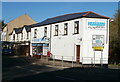
Abersychan Pharmacy
Located on Broad Street, near the corner of Old Road.
Image: © Jaggery
Taken: 25 Oct 2010
0.08 miles
10
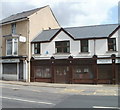
Retirement sale, Jody's, Abersychan
Ladies' and babies' fashion shop at 12 Broad Street, near the Union Street junction. Signs in the windows announce a retirement sale.
Image: © Jaggery
Taken: 16 Apr 2011
0.08 miles