IMAGES TAKEN NEAR TO
Elizabeth Row, PONTYPOOL, NP4 7US
Introduction
This page details the photographs taken nearby to Elizabeth Row, NP4 7US by members of the Geograph project.
The Geograph project started in 2005 with the aim of publishing, organising and preserving representative images for every square kilometre of Great Britain, Ireland and the Isle of Man.

There are currently over 7.5m images from over14,400 individuals and you can help contribute to the project by visiting https://www.geograph.org.uk
Image Map (Loading...)


Getting Data...Please wait
Leaflet Map data © OpenStreetMap
Images are licensed for reuse under creativecommons.org/licenses/by-sa/2.0
Notes
- Clicking on the map will re-center to the selected point.
- The higher the marker number, the further away the image location is from the centre of the postcode.
Image Listing (16 Images Found)
Images are licensed for reuse under creativecommons.org/licenses/by-sa/2.0
Image
Details
Distance
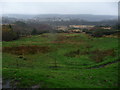
1
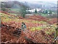
British hamlet
“British” is the name of the hamlet on the edge of old mining remains.
Image: © Graham Horn
Taken: 3 Feb 2008
0.05 miles
2
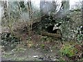
Old brick kiln?
Alongside an old mine access road.
Image: © Graham Horn
Taken: 3 Feb 2008
0.12 miles
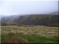
3
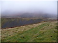
Old coal tips above Abersychan
Spoil heaps and waste tips blend in with the weather here.
Image: © Jeremy Bolwell
Taken: 24 Nov 2012
0.14 miles
4
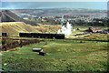
A very British scene ? 1968
This is not to disparage the Welsh – British is the name of the small mining/ironworking community from which the view is taken.
Despite appearances, this is a passenger train, not a freight train. Known as the 'paddy', it is waiting take miners up to the remote Blaenserchan Colliery, deep in a side valley above Talywain.
The extent of waste ground indicates the extent to the which the local mining and ironworking industry had declined even by the 1960s, with only Blaenserchan Colliery remaining of local pits. The area above the train was once occupied by the British Iron Works, which had ceased operating as early as 1900, with the site partly filled out with spoil from the neighbouring Lower Navigation Colliery, which itself ceased operation in 1947. The building to the right of the train is the locomotive shed – known as Big Arch - for the network of non-BR lines which had served the area, and its size indicates how important it had been. At the back of it can be seen the beam engine house of 1845, which survives in roofless condition. By this stage the shed only had 3 locomotives left, with only two in active use. The locomotive is 'Llewellyn' built by Hunslet Engineering works no.3817 in 1954 and is the standard 'Austerity' design used extensively by the National Coal Board.
Above the train can be seen the goods shed and signal box at Abersychan and Talywain Station, originally the terminus of the LNWR Abersychan Extension south from Blaenavon, later met by a GWR from the south. This closed to passengers in 1941 and to goods in 1954, although the line remained open to serve Blaenavon Big Pit until 1980. This site http://www.industrialgwent.co.uk/a42-british/index.htm has an excellent overview of the local industrial history.
Image: © Alan Murray-Rust
Taken: 1 Jan 1968
0.15 miles
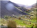
5
Old tips above Abersychan
A rare sight these days; old coal tips, un-landscaped, black and proud.
Image: © Jeremy Bolwell
Taken: 24 Nov 2012
0.16 miles
6
Mine spoil heaps
The evidence of Abersychan mine, with a disused chimney behind, which is just in the next square.
Image: © Graham Horn
Taken: 3 Feb 2008
0.16 miles
7
Former coal mining area known as British
Image: © Ruth Sharville
Taken: 28 Jul 2014
0.18 miles
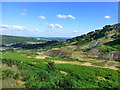
8
Scene above Abersychan
An upland South Wales Valley scene; terraced homes, disused colliery sites, industrial dereliction and nature trying to reclaim wasteland. The weather seems suitably sad and dismal.
Image: © Jeremy Bolwell
Taken: 24 Nov 2012
0.19 miles
9
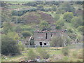
Dereliction at The British
The remains of what is thought to be the former NCB's Area Estate Office.
Image: © Gareth James
Taken: 15 Oct 2011
0.20 miles
10
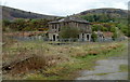
A corner of the ruined former British Ironworks offices and foundry, Abersychan
http://www.geograph.org.uk/photo/3409412 to another view and some details.
Image: © Jaggery
Taken: 16 Apr 2011
0.20 miles