IMAGES TAKEN NEAR TO
Pembroke Place, PONTYPOOL, NP4 7UL
Introduction
This page details the photographs taken nearby to Pembroke Place, NP4 7UL by members of the Geograph project.
The Geograph project started in 2005 with the aim of publishing, organising and preserving representative images for every square kilometre of Great Britain, Ireland and the Isle of Man.

There are currently over 7.5m images from over14,400 individuals and you can help contribute to the project by visiting https://www.geograph.org.uk
Image Map
Images are licensed for reuse under creativecommons.org/licenses/by-sa/2.0
Notes
- Clicking on the map will re-center to the selected point.
- The higher the marker number, the further away the image location is from the centre of the postcode.
Image Listing (45 Images Found)
Images are licensed for reuse under creativecommons.org/licenses/by-sa/2.0
Image
Details
Distance
1
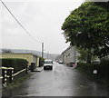
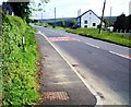
Salisbury Terrace, Varteg
From the B4246 Varteg Road, Salisbury Terrace leads to Pembroke Place and Pembroke Terrace.
Viewed during a heavy rain shower on May 11th 2017.
Image: © Jaggery
Taken: 11 May 2017
0.04 miles
2
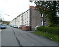
Salisbury Terrace, Varteg
Viewed from the corner of the B4246. Salisbury Terrace consists of 20 houses in one row. The houses face a field.
Varteg is a hamlet about 1,000 feet (c305 metres) above sea level, located to the north of Pontypool and south of Blaenavon.
Image: © Jaggery
Taken: 17 Jul 2011
0.05 miles
3
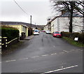
WNW along Salisbury Terrace, Varteg
From the B4246 Varteg Road, Salisbury Terrace leads to Pembroke Place and Pembroke Terrace.
Image: © Jaggery
Taken: 15 Mar 2018
0.07 miles
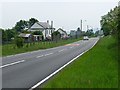
4
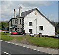
Crown Hotel, Varteg
Pub with bed and breakfast accommodation available.
Located alongside the B4246 Varteg Road.
Image: © Jaggery
Taken: 12 May 2010
0.08 miles
5
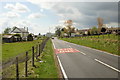
Welcome to Varteg
The B4246 from Blaenavon approaches Varteg. Just beyond the SLOW/ARAF markings in the road, a welcome sign shows Varteg and Garndiffaith. The latter village is about a kilometre south of Varteg.
The white building on the left is the Crown Hotel. http://www.geograph.org.uk/photo/1855453
Image: © Jaggery
Taken: 12 May 2010
0.08 miles
6
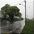
Varteg Road from Varteg towards Blaenavon
Looking north along the B4246 Varteg Road during heavy rain on May 11th 2017.
The road here is about 340 metres (c1,115 ft) above mean sea level.
Image: © Jaggery
Taken: 11 May 2017
0.11 miles
8
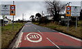
Varteg and Garndiffaith Welcome sign
Facing southbound traffic on the B4246 from Blaenavon. The National Speed Limit drops to 30mph.
Image: © Jaggery
Taken: 15 Mar 2018
0.11 miles
9
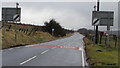
End of the 30 zone at the northern edge of Varteg
The 30mph speed limit on the B4246 Varteg Road increases to the National Speed Limit.
Image: © Jaggery
Taken: 15 Mar 2018
0.11 miles
10
Entering Varteg from the north
This is the B4246.
The sign says "Welcome Varteg and Garndiffaith Croeso".
On the left is Crown Inn.
Image: © Robin Drayton
Taken: 5 Jun 2010
0.12 miles