IMAGES TAKEN NEAR TO
Pantglas, PONTYPOOL, NP4 7TX
Introduction
This page details the photographs taken nearby to Pantglas, NP4 7TX by members of the Geograph project.
The Geograph project started in 2005 with the aim of publishing, organising and preserving representative images for every square kilometre of Great Britain, Ireland and the Isle of Man.

There are currently over 7.5m images from over14,400 individuals and you can help contribute to the project by visiting https://www.geograph.org.uk
Image Map
Images are licensed for reuse under creativecommons.org/licenses/by-sa/2.0
Notes
- Clicking on the map will re-center to the selected point.
- The higher the marker number, the further away the image location is from the centre of the postcode.
Image Listing (41 Images Found)
Images are licensed for reuse under creativecommons.org/licenses/by-sa/2.0
Image
Details
Distance
1
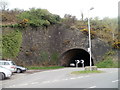
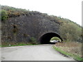
Grade II listed The Big Arch, Abersychan
Located at a sharp bend in the B4246. At a time before the B4246 existed here, the arch carried a railway line on an embankment across another railway line running through the arch. The trackbed of the higher-level line is now a cycleway and footpath. The railway lines were in industrial use, in the British Ironworks site.
The Big Arch was Grade II listed in September 1994.
Image: © Jaggery
Taken: 16 Apr 2011
0.11 miles
2
The Promenade, Abersychan
A view to the WNW along The Promenade from the edge of Pentwyn.
In the distance is Grade II listed The Big Arch. http://www.geograph.org.uk/photo/2928155
Image: © Jaggery
Taken: 16 Apr 2011
0.11 miles
3

Cattle grid across a road in the disused British Ironworks site, Abersychan
The site is to the west of Abersychan, accessed through this arch. http://www.geograph.org.uk/photo/2928155
Image: © Jaggery
Taken: 16 Apr 2011
0.13 miles
4
Railway arch
This is a disused railway arch for a railway that doesn't even appear on OS as disused!
Image: © Nick Mutton 01329 000000
Taken: 16 Sep 2007
0.16 miles
5
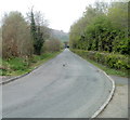
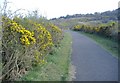
Bench on The Promenade, Abersychan
Viewed across the B4246 Lodge Road. The Promenade name sign is on the left.
Although promenade is often used for a paved public walk along a seafront at a resort,
it can also be used for a similar walk elsewhere.
This promenade is 23km north of the South Wales coast.
Image: © Jaggery
Taken: 29 Sep 2015
0.16 miles
6
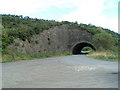
West side of Grade II listed The Big Arch, Abersychan
Viewed from the disused British Ironworks site looking towards the B4246 Lodge Road.
http://www.geograph.org.uk/photo/2928155 to a view of the other side and some details.
Image: © Jaggery
Taken: 16 Apr 2011
0.16 miles
7
Looking back through the railway arch
Image: © Nick Mutton 01329 000000
Taken: 16 Sep 2007
0.17 miles
8
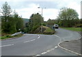
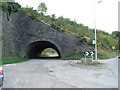
A bend in Lodge Road, Abersychan
There is a sharp bend in the course of the B4246 Lodge Road as it passes The Big Arch. http://www.geograph.org.uk/photo/2928155
The Promenade is on the right.
Image: © Jaggery
Taken: 16 Apr 2011
0.18 miles
10
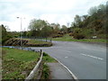
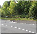
Junction of The Promenade and Lodge Road Abersychan
The B4246 Lodge Road on the left descends into Abersychan. The Promenade heads towards Pentwyn.
Image: © Jaggery
Taken: 16 Apr 2011
0.18 miles