IMAGES TAKEN NEAR TO
Pentwyn, Abersychan, PONTYPOOL, NP4 7SY
Introduction
This page details the photographs taken nearby to NP4 7SY by members of the Geograph project.
The Geograph project started in 2005 with the aim of publishing, organising and preserving representative images for every square kilometre of Great Britain, Ireland and the Isle of Man.

There are currently over 7.5m images from over14,400 individuals and you can help contribute to the project by visiting https://www.geograph.org.uk
Image Map
Images are licensed for reuse under creativecommons.org/licenses/by-sa/2.0
Notes
- Clicking on the map will re-center to the selected point.
- The higher the marker number, the further away the image location is from the centre of the postcode.
Image Listing (24 Images Found)
Images are licensed for reuse under creativecommons.org/licenses/by-sa/2.0
Image
Details
Distance
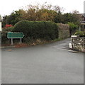
1
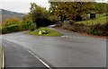
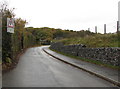
Triangular road junction in Pentwyn, Torfaen
Pentwyn Road is on the camera side.
Pentrepiod Road is beyond the left side of the junction.
The road behind the broken white lines leads to a dead-end side road.
The Pentwyn boundary sign https://www.geograph.org.uk/photo/5967691 is on the grass triangle.
Image: © Jaggery
Taken: 6 Nov 2018
0.05 miles
2
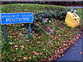
Pentwyn boundary sign, Torfaen
On this https://www.geograph.org.uk/photo/5967685 grass triangle.
Image: © Jaggery
Taken: 6 Nov 2018
0.06 miles
3
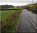
Road, pavement and fields, Pontnewynydd
Pentrepiod Road is on the right. Pontnewynydd Cricket Club clubhouse https://www.geograph.org.uk/photo/5967709 is in the background on the left.
Image: © Jaggery
Taken: 6 Nov 2018
0.08 miles
4
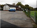
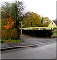
Pontnewynydd Cricket Club clubhouse
Set back from the north side of Pentrepiod Road.
Image: © Jaggery
Taken: 6 Nov 2018
0.10 miles
5
Warning sign - no footway for 670 yards, Pentrepiod Road, Pontnewynydd
On the right, stones inside metal meshing reinforce a small roadside bank.
Image: © Jaggery
Taken: 6 Nov 2018
0.14 miles
6
Early November 2018 colours, Pentwyn, Torfaen
Viewed across Pentwyn Road on November 6th 2018.
Image: © Jaggery
Taken: 6 Nov 2018
0.15 miles
7
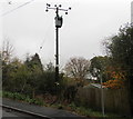
Western Power Distribution line spur pole, Pentwyn Road, Pentwyn, Torfaen
Part of the Western Power Distribution electricity supply infrastructure.
Image: © Jaggery
Taken: 6 Nov 2018
0.16 miles
8
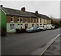
Row of houses, Pentwyn Road, Pentwyn, Torfaen
In the background here. https://www.geograph.org.uk/photo/6304191
Image: © Jaggery
Taken: 6 Nov 2018
0.17 miles
9
Ty Ceirios Nursing Home & Day Care direction sign, Pontnewynydd
The dark green sign alongside Pentrepiod Road shows the way to Ty Ceirios.
Image: © Jaggery
Taken: 6 Nov 2018
0.18 miles
10
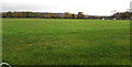
Pontnewynydd Cricket Club cricket ground
Viewed from the gate here. https://www.geograph.org.uk/photo/5967709
Image: © Jaggery
Taken: 6 Nov 2018
0.19 miles