IMAGES TAKEN NEAR TO
Ty Gwyn Road, PONTYPOOL, NP4 7SR
Introduction
This page details the photographs taken nearby to Ty Gwyn Road, NP4 7SR by members of the Geograph project.
The Geograph project started in 2005 with the aim of publishing, organising and preserving representative images for every square kilometre of Great Britain, Ireland and the Isle of Man.

There are currently over 7.5m images from over14,400 individuals and you can help contribute to the project by visiting https://www.geograph.org.uk
Image Map
Images are licensed for reuse under creativecommons.org/licenses/by-sa/2.0
Notes
- Clicking on the map will re-center to the selected point.
- The higher the marker number, the further away the image location is from the centre of the postcode.
Image Listing (108 Images Found)
Images are licensed for reuse under creativecommons.org/licenses/by-sa/2.0
Image
Details
Distance
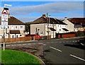
1
Ty-Gwyn Road, Varteg
Viewed from Lower Ty-Gwyn Road, Garndiffaith, across Lasgarn View.
Varteg to the north and Garndiffaith to the south are contiguous villages in Torfaen County Borough. It is unclear to this visitor exactly where the village boundary is. From various online street location references, it appears that this part of Lasgarn View marks the boundary here.
Image: © Jaggery
Taken: 25 Sep 2015
0.02 miles
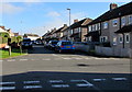
2

North along Ty Gwyn Road, Varteg
Viewed from the Lasgarn View/Lower Ty Gwyn Road crossroads.
Image: © Jaggery
Taken: 16 Jul 2018
0.02 miles
3
Grass triangle on a Garndiffaith corner
On July 16th 2018 the grassy area on the corner of Lasgarn View and Ty Gwyn Road is more yellow than green.
Image: © Jaggery
Taken: 16 Jul 2018
0.04 miles
4
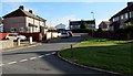
Penylan Road houses, Varteg
Looking NE towards the Ty-Gwyn Road junction. Varteg is an upland village in the county borough of Torfaen, between Pontypool and Blaenavon. The location seen here is 320 metres (1,050ft) above sea level.
Image: © Jaggery
Taken: 25 Sep 2015
0.04 miles
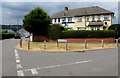
5
Penylan Road, Varteg
Viewed across the B4246 Varteg Road.
This is one of two junctions of Penylan Road and Varteg Road in Varteg.
The other one http://www.geograph.org.uk/photo/5443774 is 170 metres to the north.
Image: © Jaggery
Taken: 28 Jun 2017
0.04 miles
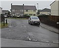
6
Humps to the right and more to the left, Varteg
The sign showing humps for 35 yards (along Penylan Road) to the right and for 210 yards to the left is on the corner of Lasgarn View. This location is either at the southern edge of Varteg or the northern edge of Garndiffaith. There are no boundary signs nearby to settle the matter.
Image: © Jaggery
Taken: 25 Sep 2015
0.05 miles
7
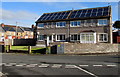
Penylan Road solar panels, Varteg
Ideally situated on a south-facing roof.
Image: © Jaggery
Taken: 25 Sep 2015
0.05 miles
8
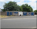
Fenced-off row of lockup garages in Varteg
Viewed across Lasgarn View in July 2018.
Image: © Jaggery
Taken: 16 Jul 2018
0.06 miles
9
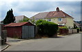
Rusty corrugated metal lockup garage on a Garndiffaith corner
On the corner of Lasgarn View and this https://www.geograph.org.uk/photo/5849385 lane.
Image: © Jaggery
Taken: 16 Jul 2018
0.06 miles
10
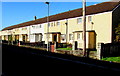
Sunny side of the street, Lasgarn View, Varteg
East-facing 65-metre long row of houses in sunshine at 9.15 am in late September 2015.
Image: © Jaggery
Taken: 25 Sep 2015
0.06 miles