IMAGES TAKEN NEAR TO
Penylan Road, PONTYPOOL, NP4 7SG
Introduction
This page details the photographs taken nearby to Penylan Road, NP4 7SG by members of the Geograph project.
The Geograph project started in 2005 with the aim of publishing, organising and preserving representative images for every square kilometre of Great Britain, Ireland and the Isle of Man.

There are currently over 7.5m images from over14,400 individuals and you can help contribute to the project by visiting https://www.geograph.org.uk
Image Map
Images are licensed for reuse under creativecommons.org/licenses/by-sa/2.0
Notes
- Clicking on the map will re-center to the selected point.
- The higher the marker number, the further away the image location is from the centre of the postcode.
Image Listing (116 Images Found)
Images are licensed for reuse under creativecommons.org/licenses/by-sa/2.0
Image
Details
Distance
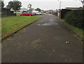
1
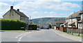
Penylan Road, Varteg
The view south from the corner of Lasgarn View.
Image: © Jaggery
Taken: 14 Jul 2011
0.03 miles
2
Lower Ty-Gwyn Road, Garndiffaith
On the south side of Lasgarn View. I thought I was still in Varteg (I'd passed no boundary signs) but various online sources state that Lower Ty-Gwyn Road is in Garndiffaith. I should have expected something like this, in view of this boundary sign http://www.geograph.org.uk/photo/2162764 on the main road north of here which shows the names of both villages.
Image: © Jaggery
Taken: 25 Sep 2015
0.04 miles
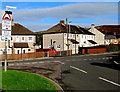
3
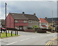
Corner of Varteg Road and Penylan Road, Varteg
Looking in the direction of Garndiffaith.
Image: © Jaggery
Taken: 12 May 2010
0.04 miles
4
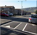
Penylan Road speed bumps, Varteg
Traffic calming on a village street in the county borough of Torfaen.
This location is either at the southern edge of Varteg or the northern edge of Garndiffaith. There are no boundary signs nearby to settle the matter.
Image: © Jaggery
Taken: 25 Sep 2015
0.04 miles
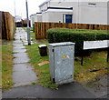
5
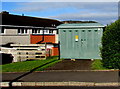
Penylan Road electricity substation, Varteg
The Western Power Distribution electricity substation identifier is PENYLAN ROAD S/S 53-2697.
Image: © Jaggery
Taken: 25 Sep 2015
0.05 miles
6
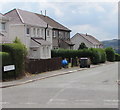
South along Lower Ty Gwyn Road, Garndiffaith
Viewed from the Lasgarn View/Ty Gwyn Road crossroads.
Image: © Jaggery
Taken: 16 Jul 2018
0.06 miles
7
Path into Woodland View, Varteg
From the B4246 into Woodland View, an area of flats between Varteg Road and Penylan Road.
The sign on the right shows that Woodland View is Trem y Goedlan in Welsh.
Image: © Jaggery
Taken: 28 Jun 2017
0.06 miles
8
Humps to the right and more to the left, Varteg
The sign showing humps for 35 yards (along Penylan Road) to the right and for 210 yards to the left is on the corner of Lasgarn View. This location is either at the southern edge of Varteg or the northern edge of Garndiffaith. There are no boundary signs nearby to settle the matter.
Image: © Jaggery
Taken: 25 Sep 2015
0.06 miles
9
Road from Varteg Road to Penylan Road, Varteg
Side road past the backs of Herbert's Road houses.
Image: © Jaggery
Taken: 28 Jun 2017
0.07 miles
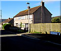
10
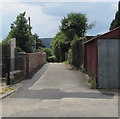
Lane towards Ty Rosser Gwyn, Garndiffaith
From the south side of Lasgarn View.
Image: © Jaggery
Taken: 16 Jul 2018
0.07 miles