IMAGES TAKEN NEAR TO
Herberts Close, PONTYPOOL, NP4 7QD
Introduction
This page details the photographs taken nearby to Herberts Close, NP4 7QD by members of the Geograph project.
The Geograph project started in 2005 with the aim of publishing, organising and preserving representative images for every square kilometre of Great Britain, Ireland and the Isle of Man.

There are currently over 7.5m images from over14,400 individuals and you can help contribute to the project by visiting https://www.geograph.org.uk
Image Map
Images are licensed for reuse under creativecommons.org/licenses/by-sa/2.0
Notes
- Clicking on the map will re-center to the selected point.
- The higher the marker number, the further away the image location is from the centre of the postcode.
Image Listing (84 Images Found)
Images are licensed for reuse under creativecommons.org/licenses/by-sa/2.0
Image
Details
Distance
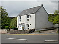
1
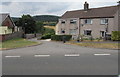
Herbert's Close semis, Garndiffaith
Semi-detached houses viewed across Herbert's Road. The edge of Garn Workman's Club https://www.geograph.org.uk/photo/5844141 is on the left.
Image: © Jaggery
Taken: 16 Jul 2018
0.01 miles
2
Telecoms cabinet on a Garndiffaith corner
The dark green cabinet is on the corner of Herbert's Road and
Herbert's Close at the edge of Garn Workman's Club. https://www.geograph.org.uk/photo/5844141
Image: © Jaggery
Taken: 16 Jul 2018
0.03 miles
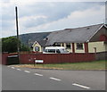
3
Garn Workman's Club, Garndiffaith
The Herbert's Road side of the club on the corner of Herbert's Close.
https://www.geograph.org.uk/photo/5844145 to the information board.
Image: © Jaggery
Taken: 16 Jul 2018
0.03 miles
4
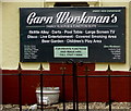
Garn Workman's Club information board, Garndiffaith
Located here. https://www.geograph.org.uk/photo/5844141 Viewed in July 2018.
Image: © Jaggery
Taken: 16 Jul 2018
0.04 miles
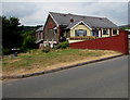
5
Birchill Cottage, Garndiffaith
Located on New Road (B4246)
Image: © Jaggery
Taken: 12 May 2010
0.04 miles
6
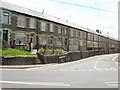
Co-operative Terrace, Garndiffaith
The New Road (B4246) end of Herberts Road has a long line of terraced houses, which have their own name plate, Co-operative Terrace, on the pavement, adjacent to the Herberts Road name plate.
Image: © Jaggery
Taken: 12 May 2010
0.06 miles
7
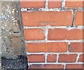
Ordnance Survey Cut Mark
This OS cut mark can be found on the wall of the old Police Station, Herberts Road. It marks a point 287.676m above mean sea level.
Image: © Adrian Dust
Taken: 25 Aug 2019
0.06 miles
8
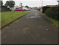
Road from Varteg Road to Penylan Road, Varteg
Side road past the backs of Herbert's Road houses.
Image: © Jaggery
Taken: 28 Jun 2017
0.07 miles
9
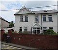
Former Garndiffaith Police Station
The plaque on the house on the east side of Herbert's Road in Garndiffaith shows POLICE STATION 1910.
Image: © Jaggery
Taken: 16 Jul 2018
0.07 miles
10
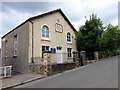
Bethel Methodist Church, Herbert's Road, Garndiffaith
In 2018 the church is part of the Gwent Hills and Vales Methodist Circuit.
The tablet https://www.geograph.org.uk/photo/5844235 on the church wall shows BETHEL PRIMITIVE METHODIST CHAPEL A.D. 1849.
Image: © Jaggery
Taken: 16 Jul 2018
0.08 miles