IMAGES TAKEN NEAR TO
Varteg Road, PONTYPOOL, NP4 7PY
Introduction
This page details the photographs taken nearby to Varteg Road, NP4 7PY by members of the Geograph project.
The Geograph project started in 2005 with the aim of publishing, organising and preserving representative images for every square kilometre of Great Britain, Ireland and the Isle of Man.

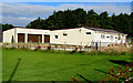
There are currently over 7.5m images from over14,400 individuals and you can help contribute to the project by visiting https://www.geograph.org.uk
Image Map
Images are licensed for reuse under creativecommons.org/licenses/by-sa/2.0
Notes
- Clicking on the map will re-center to the selected point.
- The higher the marker number, the further away the image location is from the centre of the postcode.
Image Listing (111 Images Found)
Images are licensed for reuse under creativecommons.org/licenses/by-sa/2.0
Image
Details
Distance
1
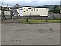
North side of Watkins Funeral Home, Varteg, Torfaen
Set back from the west side of the B4246 Varteg Road, viewed from Varteg Bus Terminus.
Image: © Jaggery
Taken: 28 Jun 2022
0.02 miles
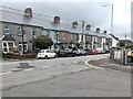
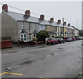
2
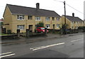
Varteg Road houses, Varteg
On the east side of the B4246 Varteg Road, between Samson's Avenue and Penylan Road.
Image: © Jaggery
Taken: 28 Jun 2017
0.03 miles
3
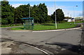
Varteg Terminus and turning area
Located on the west side of the B4246 Varteg Road, this is the northern terminus of Stagecoach route 23 from Cwmbran. It is also used by buses on route X24 (and route 24 on Sundays) but only by southbound buses. Northbound X24 and 24 buses use the stop alongside the B4246 bench on the right.
Image: © Jaggery
Taken: 25 Sep 2015
0.03 miles
4
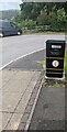
Litter & dog waste bin, Varteg, Torfaen
Text on the bin shows that dog waste is gwastraff ci in Welsh.
Image: © Jaggery
Taken: 28 Jun 2022
0.03 miles
5
Watkins Funeral Home, Varteg
Set back from the west side of the B4246 Varteg Road.
Image: © Jaggery
Taken: 25 Sep 2015
0.03 miles
6
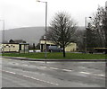
Varteg Terminus
Bus stop on the west side of the B4246 Varteg Road.
Image: © Jaggery
Taken: 12 Dec 2019
0.03 miles
7
Row of houses, Varteg, Torfaen
Viewed across the B4246 Varteg Road.
Image: © Jaggery
Taken: 28 Jun 2022
0.03 miles
8
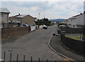
South along Penylan Road, Varteg
Viewed from this https://www.geograph.org.uk/photo/5845920 Samson's Avenue bus stop.
Image: © Jaggery
Taken: 16 Jul 2018
0.03 miles
9
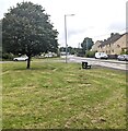
Tree on grass, Varteg, Torfaen
The B4246 Varteg Road is on the right.
Image: © Jaggery
Taken: 28 Jun 2022
0.03 miles
10
Row of houses, Varteg Road, Varteg
The row extends for 60 metres along the east side of the B4246 Varteg Road.
The Penylan Road junction http://www.geograph.org.uk/photo/5443774 is on the left.
Image: © Jaggery
Taken: 28 Jun 2017
0.04 miles