1
Harper's Road & Belvedere
Viewed from cycle track, NCR 492, on bridge over road.
Image: © M J Roscoe
Taken: 25 Feb 2022
0.03 miles
2
Information board and signpost at Harper's Road
Cycle track, NCR 492, board on former LNWR railway at exit to Harper's Road.
Image: © M J Roscoe
Taken: 25 Feb 2022
0.04 miles
3
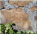
Ordnance Survey Cut Mark
This OS cut mark can be found on the wall NW side of Stanley Road. It marks a point 269.523m above mean sea level.
Image: © Adrian Dust
Taken: 25 Aug 2019
0.05 miles
4
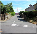
Stanley Road towards Top Road, Garndiffaith
Image: © Jaggery
Taken: 19 Jul 2018
0.05 miles
5
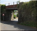
Former railway bridge over Harper's Road, Garndiffaith
Headroom of 4.4 metres (14' 6") is shown on the bridge over Harper's Road. The former railway on the bridge is now part of National Cycle Network Route 492 from Cwmbran towards Brynmawr via Blaenavon.
Image: © Jaggery
Taken: 19 Jul 2018
0.05 miles
6
East side of a former railway bridge over Harper's Road, Garndiffaith
The former railway on the bridge is now part of National Cycle Network Route 492 from Cwmbran towards Brynmawr via Blaenavon.
Image: © Jaggery
Taken: 19 Jul 2018
0.06 miles
7
Visibility mirror on the wall of a former railway bridge, Garndiffaith
On the wall of this https://www.geograph.org.uk/photo/5848080 bridge over a bend in Harper's Road.
Image: © Jaggery
Taken: 19 Jul 2018
0.06 miles
8
Ordnance Survey Rivet
This OS rivet can be found on the railway bridge, Harpers Road. It marks a point 255.782m above mean sea level.
Image: © Adrian Dust
Taken: 25 Aug 2019
0.06 miles
9
Queen Elizabeth II postbox, Stanley Road, Garndiffaith
On the corner of two branches or arms of Stanley Road.
Image: © Jaggery
Taken: 19 Jul 2018
0.06 miles
10
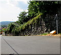
Yellow grit box alongside Harper's Road Garndiffaith
On the ascent towards this https://www.geograph.org.uk/photo/5848083 former railway bridge.
Image: © Jaggery
Taken: 19 Jul 2018
0.06 miles


