IMAGES TAKEN NEAR TO
Heol Waun, PONTYPOOL, NP4 7JZ
Introduction
This page details the photographs taken nearby to Heol Waun, NP4 7JZ by members of the Geograph project.
The Geograph project started in 2005 with the aim of publishing, organising and preserving representative images for every square kilometre of Great Britain, Ireland and the Isle of Man.

There are currently over 7.5m images from over14,400 individuals and you can help contribute to the project by visiting https://www.geograph.org.uk
Image Map
Images are licensed for reuse under creativecommons.org/licenses/by-sa/2.0
Notes
- Clicking on the map will re-center to the selected point.
- The higher the marker number, the further away the image location is from the centre of the postcode.
Image Listing (115 Images Found)
Images are licensed for reuse under creativecommons.org/licenses/by-sa/2.0
Image
Details
Distance
1

Heol Waun, Talywain
Cul-de-sac on the NW side of the B4246 Church Road.
Image: © Jaggery
Taken: 29 Sep 2015
0.02 miles
2
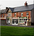
Talywain Stores and Post Office
At 79 Commercial Road, Talywain. Family Pizza House http://www.geograph.org.uk/photo/4680026 at number 77 is on the left.
Image: © Jaggery
Taken: 29 Sep 2015
0.02 miles
3

Talywain Post Office
Post Office and stores at 79 Commercial Road.
Image: © Jaggery
Taken: 12 May 2010
0.02 miles
4
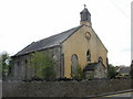
Decaying church of St Thomas, Talywain
Located on the corner of Commercial Road and Bluett's Road.
The church, built in 1832 in the Early English style, appears to have been unused for several years. There are signs http://www.geograph.org.uk/photo/1857637 at the perimeter warning that the churchyard is unsafe. The entrance gate is padlocked.
Image: © Jaggery
Taken: 12 May 2010
0.02 miles
5
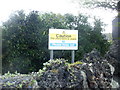
Churchyard unsafe - please keep out
Sign at the perimeter wall of the derelict church of St Thomas http://www.geograph.org.uk/photo/1857620 Talywain.
Image: © Jaggery
Taken: 12 May 2010
0.02 miles
6
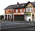
Family Pizza House, Talywain
The takeaway at 77 Commercial Road sells pizzas, kebabs, burgers, fish & chips etc.
Image: © Jaggery
Taken: 29 Sep 2015
0.02 miles
7
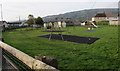
Children's playground, Talywain
Between Commercial Road and Heol Waun (ahead).
Image: © Jaggery
Taken: 29 Sep 2015
0.03 miles
8

Commercial Road electricity substation, Talywain
The Western Power Distribution electricity substation is inside a fenced compound on the west side of the B4246 Commercial Road between a children's playground and a small row of shops.
Image: © Jaggery
Taken: 29 Sep 2015
0.03 miles
9
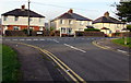
Commercial Road semis in Talywain
Semi-detached houses on the west side of the B4246 Commercial Road (Heol Fasnach in Welsh).
Image: © Jaggery
Taken: 29 Sep 2015
0.03 miles
10
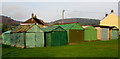
Corrugated metal buildings, Heol Waun, Talywain
Viewed from Commercial Road. A row of similar buildings is immediately behind these, on the Heol Waun side.
Image: © Jaggery
Taken: 29 Sep 2015
0.04 miles