IMAGES TAKEN NEAR TO
Pisgah Road, PONTYPOOL, NP4 7HZ
Introduction
This page details the photographs taken nearby to Pisgah Road, NP4 7HZ by members of the Geograph project.
The Geograph project started in 2005 with the aim of publishing, organising and preserving representative images for every square kilometre of Great Britain, Ireland and the Isle of Man.

There are currently over 7.5m images from over14,400 individuals and you can help contribute to the project by visiting https://www.geograph.org.uk
Image Map
Images are licensed for reuse under creativecommons.org/licenses/by-sa/2.0
Notes
- Clicking on the map will re-center to the selected point.
- The higher the marker number, the further away the image location is from the centre of the postcode.
Image Listing (106 Images Found)
Images are licensed for reuse under creativecommons.org/licenses/by-sa/2.0
Image
Details
Distance
1
Barrier across a Talywain path near Pisgah Road
To access this path http://www.geograph.org.uk/photo/4679696 walkers can pass through the inwardly-sloping barrier on the right.
Image: © Jaggery
Taken: 29 Sep 2015
0.04 miles
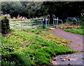
2
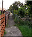
Footpath between houses, Talywain
Between two rows of houses aligned at right angles to the east side of the B4246 Commercial Road.
Image: © Jaggery
Taken: 29 Sep 2015
0.05 miles
3
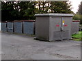
Pisgah Road electricity substation, Talywain
The Western Power Distribution electricity substation identifier is
PISGAH ROAD TALYWAIN S/S No 53-2605.
Image: © Jaggery
Taken: 29 Sep 2015
0.05 miles
4
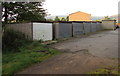
Row of lockup garages, Talywain
South of Pisgah Road. The back of an electricity substation http://www.geograph.org.uk/photo/4679644 is in the background.
Image: © Jaggery
Taken: 29 Sep 2015
0.05 miles
5
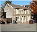
Pisgah House, Pisgah Road, Talywain
Semi-detached houses on Pisgah Road, next door to the Sunday School http://www.geograph.org.uk/photo/2137289 and Baptist Church.http://www.geograph.org.uk/photo/2137313
Nearest the camera is Pisgah House. The other half of the building is Papworth House.
Image: © Jaggery
Taken: 25 Oct 2010
0.05 miles
6
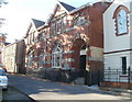
Pisgah Sunday School, Talywain
Located on Pisgah Road, next door to the Baptist Church, on the right. http://www.geograph.org.uk/photo/2137313
The date inscribed above the doorway is 1909.
Image: © Jaggery
Taken: 25 Oct 2010
0.05 miles
7
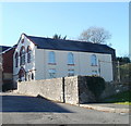
Pisgah Baptist Church, Talywain
Located on Pisgah Road. Inscribed in stone above the three windows on the front of the church are 1827.1930 - presumably built in 1827, major rebuild in 1930. Behind the church is the Sunday School. http://www.geograph.org.uk/photo/2137289
Image: © Jaggery
Taken: 25 Oct 2010
0.05 miles
8
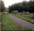
Path towards Nant Ffrwd, Talywain
Viewed from near this http://www.geograph.org.uk/photo/4679665 barrier. The stream Nant Ffrwd is a tributary of a river, the Afon Lwyd.
Image: © Jaggery
Taken: 29 Sep 2015
0.05 miles
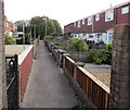
9
Path NE of Commercial Road, Talywain
Past fences at the SE edge of four parallel rows of houses south of Pisgah Road.
Image: © Jaggery
Taken: 29 Sep 2015
0.06 miles
10
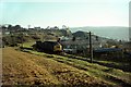
Passing the site of Garndiffaith Junction ? 1969
Type 3 (Class 37) locomotive with a short train of mineral wagons descends the line from Big Pit, Blaenavon. This was the former LNWR Abersychan Extension branch, which had closed to general freight as early as 1954, and had subsequently been reduced to single track.
The junction, actually on the viaduct, was with industrial lines that came up the formation where the photographer is standing, serving a number of collieries on the western side of the valley as well as, originally, the British Iron Works. The line has been adapted to form a footpath and cycleway up the valley, and this view https://www.geograph.org.uk/photo/4679696 is taken at almost exactly the same location.
Image: © Alan Murray-Rust
Taken: 26 Nov 1969
0.06 miles