IMAGES TAKEN NEAR TO
Pisgah Road, PONTYPOOL, NP4 7HY
Introduction
This page details the photographs taken nearby to Pisgah Road, NP4 7HY by members of the Geograph project.
The Geograph project started in 2005 with the aim of publishing, organising and preserving representative images for every square kilometre of Great Britain, Ireland and the Isle of Man.

There are currently over 7.5m images from over14,400 individuals and you can help contribute to the project by visiting https://www.geograph.org.uk
Image Map
Images are licensed for reuse under creativecommons.org/licenses/by-sa/2.0
Notes
- Clicking on the map will re-center to the selected point.
- The higher the marker number, the further away the image location is from the centre of the postcode.
Image Listing (105 Images Found)
Images are licensed for reuse under creativecommons.org/licenses/by-sa/2.0
Image
Details
Distance
1
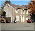
Pisgah House, Pisgah Road, Talywain
Semi-detached houses on Pisgah Road, next door to the Sunday School http://www.geograph.org.uk/photo/2137289 and Baptist Church.http://www.geograph.org.uk/photo/2137313
Nearest the camera is Pisgah House. The other half of the building is Papworth House.
Image: © Jaggery
Taken: 25 Oct 2010
0.04 miles
2
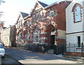
Pisgah Sunday School, Talywain
Located on Pisgah Road, next door to the Baptist Church, on the right. http://www.geograph.org.uk/photo/2137313
The date inscribed above the doorway is 1909.
Image: © Jaggery
Taken: 25 Oct 2010
0.04 miles
3
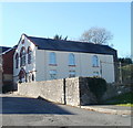
Pisgah Baptist Church, Talywain
Located on Pisgah Road. Inscribed in stone above the three windows on the front of the church are 1827.1930 - presumably built in 1827, major rebuild in 1930. Behind the church is the Sunday School. http://www.geograph.org.uk/photo/2137289
Image: © Jaggery
Taken: 25 Oct 2010
0.04 miles
4
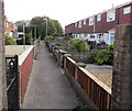
Footpath between houses, Talywain
Between two rows of houses aligned at right angles to the east side of the B4246 Commercial Road.
Image: © Jaggery
Taken: 29 Sep 2015
0.05 miles
5
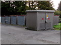
Pisgah Road electricity substation, Talywain
The Western Power Distribution electricity substation identifier is
PISGAH ROAD TALYWAIN S/S No 53-2605.
Image: © Jaggery
Taken: 29 Sep 2015
0.06 miles
6
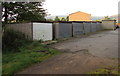
Row of lockup garages, Talywain
South of Pisgah Road. The back of an electricity substation http://www.geograph.org.uk/photo/4679644 is in the background.
Image: © Jaggery
Taken: 29 Sep 2015
0.06 miles
7
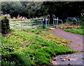
Barrier across a Talywain path near Pisgah Road
To access this path http://www.geograph.org.uk/photo/4679696 walkers can pass through the inwardly-sloping barrier on the right.
Image: © Jaggery
Taken: 29 Sep 2015
0.06 miles
8
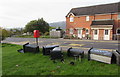
Dead wheelie bins in Talywain
Alongside an Albert Road bus stop lie wheelie bins and some of their detached wheels.
The word COPPER is on the bin on the right.
Image: © Jaggery
Taken: 29 Sep 2015
0.06 miles
9

The Globe Inn name sign, Talywain
Hanging from an ornate bracket here. http://www.geograph.org.uk/photo/1857542 Peeling paintwork has partly revealed a ghost of an earlier name. The letters HOS can be seen to the left of INN.
Image: © Jaggery
Taken: 29 Sep 2015
0.06 miles
10
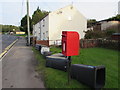
Queen Elizabeth II postbox, Albert Road, Talywain
Old wheelie bins, http://www.geograph.org.uk/photo/4678856 some without wheels, have been dumped near the postbox.
Image: © Jaggery
Taken: 29 Sep 2015
0.07 miles