IMAGES TAKEN NEAR TO
Coronation Terrace, PONTYPOOL, NP4 7HL
Introduction
This page details the photographs taken nearby to Coronation Terrace, NP4 7HL by members of the Geograph project.
The Geograph project started in 2005 with the aim of publishing, organising and preserving representative images for every square kilometre of Great Britain, Ireland and the Isle of Man.

There are currently over 7.5m images from over14,400 individuals and you can help contribute to the project by visiting https://www.geograph.org.uk
Image Map
Images are licensed for reuse under creativecommons.org/licenses/by-sa/2.0
Notes
- Clicking on the map will re-center to the selected point.
- The higher the marker number, the further away the image location is from the centre of the postcode.
Image Listing (86 Images Found)
Images are licensed for reuse under creativecommons.org/licenses/by-sa/2.0
Image
Details
Distance
1
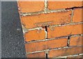
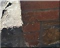
Ordnance Survey Cut Mark
This OS cut mark can be found on the wall of The Mount, Waterloo Road. It marks a point 259.449m above mean sea level.
Image: © Adrian Dust
Taken: 25 Aug 2019
0.03 miles
2
Coed Terrace, Waterloo Road, Talywain
This section of Waterloo Road is named Coed Terrace.
Image: © Jaggery
Taken: 13 Apr 2011
0.07 miles
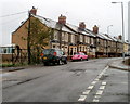
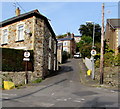
3
Corner of Wellington Road and Waterloo Road, Talywain
Viewed across Waterloo Road.
Image: © Jaggery
Taken: 13 Apr 2011
0.07 miles
4
Brynamlwg, Talywain
Recently-built houses on Brynamlwg (leading to Fairfield), viewed across Waterloo Road.
Image: © Jaggery
Taken: 13 Apr 2011
0.08 miles
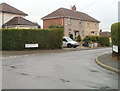
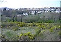
5
Waterloo Road house above a fenced-off hillside, Abersychan
Viewed from Manor Way.
Image: © Jaggery
Taken: 29 Sep 2015
0.10 miles
6
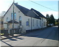
Victoria Village Methodist Church
Located on Viaduct Road. Victoria Village is a hamlet near Abersychan.
Image: © Jaggery
Taken: 25 Oct 2010
0.12 miles
7
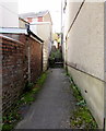
Path and steps from Manor Road to Manor Way, Abersychan
Extending for about 40 metres.
Image: © Jaggery
Taken: 29 Sep 2015
0.13 miles
9
Ordnance Survey Cut Mark
This OS cut mark can be found on No1 Pleasant View. It marks a point 236.281m above mean sea level.
Image: © Adrian Dust
Taken: 25 Aug 2019
0.13 miles
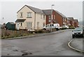
10
Waterloo Road, Abersychan
Ascending from the corner of Manor Road and Manor Way. The signs show no motor vehicles except for access.
Image: © Jaggery
Taken: 29 Sep 2015
0.13 miles