IMAGES TAKEN NEAR TO
Cleaves Terrace, Foundry Road, PONTYPOOL, NP4 7EP
Introduction
This page details the photographs taken nearby to Cleaves Terrace, Foundry Road, NP4 7EP by members of the Geograph project.
The Geograph project started in 2005 with the aim of publishing, organising and preserving representative images for every square kilometre of Great Britain, Ireland and the Isle of Man.

There are currently over 7.5m images from over14,400 individuals and you can help contribute to the project by visiting https://www.geograph.org.uk
Image Map
Images are licensed for reuse under creativecommons.org/licenses/by-sa/2.0
Notes
- Clicking on the map will re-center to the selected point.
- The higher the marker number, the further away the image location is from the centre of the postcode.
Image Listing (236 Images Found)
Images are licensed for reuse under creativecommons.org/licenses/by-sa/2.0
Image
Details
Distance
1

Red Lion Flats, Abersychan
Located on the corner of Foundry Road and Bell Lane, viewed from the western end of Union Street.
Image: © Jaggery
Taken: 16 Apr 2011
0.03 miles
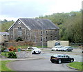
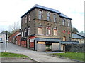
2

The Rio, Abersychan
Club on Foundry Road. Attractions shown on the sign are discotheque, skittles, billiards, pool.
Behind the club is the top of Trinity Methodist Church, High Street.
Image: © Jaggery
Taken: 16 Apr 2011
0.03 miles
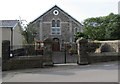
3
Trinity Methodist Church, Abersychan
High Street church dating from 1870. At the end of 2010, internal redecoration included the removal of all pews, replaced by "comfy" chairs.
Image: © Jaggery
Taken: 16 Apr 2011
0.03 miles
4
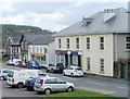
High Street shops, Abersychan
A group of shops on the south side on High Street, between Swan Square and Glansychan Lane (formerly named Factory Lane).
Image: © Jaggery
Taken: 16 Apr 2011
0.03 miles
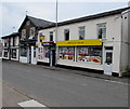
5
Pub and chip shop, High Street, Abersychan
Located at the western end of a row of High Street shops http://www.geograph.org.uk/photo/2376859 are Scam's fish and chip shop, and the New Inn pub.
Image: © Jaggery
Taken: 16 Apr 2011
0.03 miles
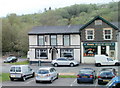
6
The New Inn, Abersychan
High Street pub viewed from the corner of Glansychan Lane (formerly Factory Lane).
The pub was formerly named the Unicorn Inn.
Image: © Jaggery
Taken: 16 Apr 2011
0.03 miles
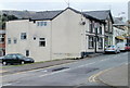
7
Derelict former Co-op, High Street, Abersychan
Located on the corner of High Street and Glansychan Lane, the building has been derelict for about 15 years. It was formerly a Co-op store with its own bakery, pharmacy, shoe shop and butcher’s shop.
Image: © Jaggery
Taken: 16 Apr 2011
0.03 miles
8
Abersychan Stores
Premier Express convenience store at 132 High Street Abersychan.
Image: © Jaggery
Taken: 16 Jul 2018
0.05 miles
9

New Inn, Abersychan
High Street pub viewed from the corner of Glansychan Lane (formerly Factory Lane).
The New Inn was formerly named the Unicorn Inn.
Image: © Jaggery
Taken: 29 Sep 2015
0.05 miles
10
Trinity Methodist Church, Abersychan
High Street church dating from 1870. http://www.geograph.org.uk/photo/2378269 to another view.
Image: © Jaggery
Taken: 29 Sep 2015
0.05 miles