IMAGES TAKEN NEAR TO
Pisgah Close, PONTYPOOL, NP4 7EJ
Introduction
This page details the photographs taken nearby to Pisgah Close, NP4 7EJ by members of the Geograph project.
The Geograph project started in 2005 with the aim of publishing, organising and preserving representative images for every square kilometre of Great Britain, Ireland and the Isle of Man.

There are currently over 7.5m images from over14,400 individuals and you can help contribute to the project by visiting https://www.geograph.org.uk
Image Map
Images are licensed for reuse under creativecommons.org/licenses/by-sa/2.0
Notes
- Clicking on the map will re-center to the selected point.
- The higher the marker number, the further away the image location is from the centre of the postcode.
Image Listing (117 Images Found)
Images are licensed for reuse under creativecommons.org/licenses/by-sa/2.0
Image
Details
Distance
1
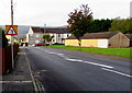
Bus stop and Emlyn Terrace houses, Talywain
A stop alongside the B4246, on the northbound X24 bus route from Newport to Blaenavon.
Image: © Jaggery
Taken: 29 Sep 2015
0.08 miles
2
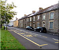
Houses at the southern end of High Street, Garndiffaith
Viewed from the junction of High Street and Viaduct Road. The southern end of High Street is more like a narrow country lane than a typical high street.
Image: © Jaggery
Taken: 25 Oct 2010
0.08 miles
3
Emlyn Road houses, Talywain
Viewed across the B4246, here named Emlyn Road. The Green Way junction is on the right.
Image: © Jaggery
Taken: 29 Sep 2015
0.08 miles
4
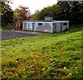
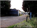
Ravine Ground pavilion, Garndiffaith
The building is above the southern edge of Fairfield United's home ground. http://www.geograph.org.uk/photo/4678677
Image: © Jaggery
Taken: 29 Sep 2015
0.09 miles
5
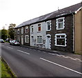
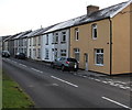
Graig View Terrace, Talywain
Row of four houses at the northern edge of Talywain, viewed across the B4246.
Image: © Jaggery
Taken: 29 Sep 2015
0.09 miles
6
Mirror Effect, Talywain
Set back from a bend in the B4246, here named Albert Road. The nameboard on the right shows
MIRROR EFFECT MOBILE VALETING AND VINYLS.
Prices displayed in late September 2015 are Bronze (vehicle) Valet from £4, Silver Valet from £10, Gold Valet from £30, Platinum Valet from £60 and Colour Restore from £80. Also available are custom stickers, wall art, vehicle wrapping, car & van signwriting, banners & signboards and clothing printing.
Image: © Jaggery
Taken: 29 Sep 2015
0.10 miles
7
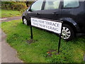
Bilingual street name sign, Graig View Terrace, Talywain
The English and Welsh names are on the north side of this http://www.geograph.org.uk/photo/4678599 row of houses.
Image: © Jaggery
Taken: 29 Sep 2015
0.10 miles
8
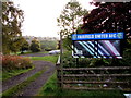
Entrance to the Ravine Ground Garndiffaith
On the east side of the B4246 Emlyn Road, this is the entrance to the Ravine Ground, http://www.geograph.org.uk/photo/4678677 the home of Fairfield United AFC (Association Football Club). Based on the location of this http://www.geograph.org.uk/photo/4678607 nearby boundary sign,
the entrance is in Talywain but most of the football ground is in Garndiffaith.
Image: © Jaggery
Taken: 29 Sep 2015
0.10 miles
9
Warning sign - minor junction on the right side of a bend, Talywain
On the approach to a bend in the B4246. The thickness of the black lines on the sign represent the relative importance of the roads. The minor road is shown as a small rectangle on the right side of the bend.
Image: © Jaggery
Taken: 29 Sep 2015
0.10 miles
10
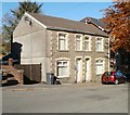
Pisgah House, Pisgah Road, Talywain
Semi-detached houses on Pisgah Road, next door to the Sunday School http://www.geograph.org.uk/photo/2137289 and Baptist Church.http://www.geograph.org.uk/photo/2137313
Nearest the camera is Pisgah House. The other half of the building is Papworth House.
Image: © Jaggery
Taken: 25 Oct 2010
0.10 miles