IMAGES TAKEN NEAR TO
Foundry Road, PONTYPOOL, NP4 7EG
Introduction
This page details the photographs taken nearby to Foundry Road, NP4 7EG by members of the Geograph project.
The Geograph project started in 2005 with the aim of publishing, organising and preserving representative images for every square kilometre of Great Britain, Ireland and the Isle of Man.

There are currently over 7.5m images from over14,400 individuals and you can help contribute to the project by visiting https://www.geograph.org.uk
Image Map
Images are licensed for reuse under creativecommons.org/licenses/by-sa/2.0
Notes
- Clicking on the map will re-center to the selected point.
- The higher the marker number, the further away the image location is from the centre of the postcode.
Image Listing (130 Images Found)
Images are licensed for reuse under creativecommons.org/licenses/by-sa/2.0
Image
Details
Distance
1
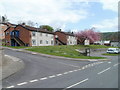
Swan Square flats, Abersychan
Flats on the south side of Swan Square, viewed across High Street. There are external stairs from the street to the upper floor flats.
Image: © Jaggery
Taken: 16 Apr 2011
0.02 miles
2
Fire-damaged former Pulse Fitness Centre, High Street, Abersychan
Satellite imagery shows extensive damage to the roof of this building, caused by a fire in October 2012.
This late September 2015 view shows a part of the damaged roof on the left.
Image: © Jaggery
Taken: 29 Sep 2015
0.04 miles
3
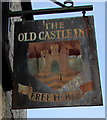
Old Castle Inn name sign, High Street, Abersychan
Hanging from a wall bracket here. http://www.geograph.org.uk/photo/4681281
The original red blue and green colours on the sign have been replaced by rust.
Image: © Jaggery
Taken: 29 Sep 2015
0.05 miles
4
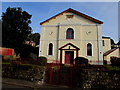
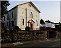
High Street Baptist Church, Abersychan
On the north side of High Street. The nameboard on the left shows High Street Baptist Church.
The inscription on the tablet high above the entrance shows
HIGH STREET BAPTIST CHAPEL 1827.
Image: © Jaggery
Taken: 29 Sep 2015
0.05 miles
5
Southwest side of High Street Baptist Church, Abersychan
The nameboard on the left shows High Street Baptist Church.
The inscription on the tablet high above the entrance shows
HIGH STREET BAPTIST CHAPEL 1827.
Image: © Jaggery
Taken: 29 Sep 2015
0.05 miles
6
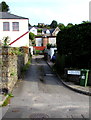
This way to Gelli Place and Rose Villas, Abersychan
Lane on the north side of High Street.
Image: © Jaggery
Taken: 29 Sep 2015
0.05 miles
7
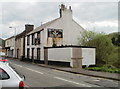
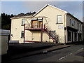
Former Old Castle Inn, Abersychan
Derelict, boarded-up and with vegetation sprouting from its chimneys, the former Old Castle Inn is at 148 High Street.
Image: © Jaggery
Taken: 16 Apr 2011
0.05 miles
8
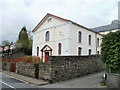
High Street Baptist Church, Abersychan
Built in 1827, the church was Grade II listed in 1997. It is located on the corner of High Street and Gelli Place.
Image: © Jaggery
Taken: 16 Apr 2011
0.05 miles
9
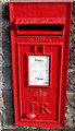
Queen Elizabeth II postbox in a High Street wall, Abersychan
The box is in a wall http://www.geograph.org.uk/photo/4681045
near the corner of Swan Square. In late September 2015,
the notice shows that the last time this box is emptied
is as early as 9am on Mondays-Fridays (7am on Saturdays).
Image: © Jaggery
Taken: 29 Sep 2015
0.05 miles
10
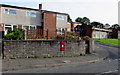
High Street postbox, Abersychan
The postbox http://www.geograph.org.uk/photo/4681026 is in a High Street wall near the corner of Swan Square.
Image: © Jaggery
Taken: 29 Sep 2015
0.05 miles