IMAGES TAKEN NEAR TO
Church Road, PONTYPOOL, NP4 7EF
Introduction
This page details the photographs taken nearby to Church Road, NP4 7EF by members of the Geograph project.
The Geograph project started in 2005 with the aim of publishing, organising and preserving representative images for every square kilometre of Great Britain, Ireland and the Isle of Man.

There are currently over 7.5m images from over14,400 individuals and you can help contribute to the project by visiting https://www.geograph.org.uk
Image Map
Images are licensed for reuse under creativecommons.org/licenses/by-sa/2.0
Notes
- Clicking on the map will re-center to the selected point.
- The higher the marker number, the further away the image location is from the centre of the postcode.
Image Listing (103 Images Found)
Images are licensed for reuse under creativecommons.org/licenses/by-sa/2.0
Image
Details
Distance
1
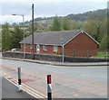
The Conifers, Abersychan
Long bungalow on the corner of Church Road and Lodge Road.
Image: © Jaggery
Taken: 16 Apr 2011
0.03 miles
2

Junction in the south of Talywain
Church Road, the B4246 from the left, descends ahead into Abersychan as an unclassified road.
The B4246 continues on the right as Lodge Road.
Image: © Jaggery
Taken: 29 Sep 2015
0.04 miles
3
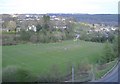
Rugby pitch, Abersychan
Sign of the times? The young Welsh lads on the pitch, were playing football!
Image: © Roger Cornfoot
Taken: 11 Apr 2007
0.04 miles
4
Bilingual name sign, Lodge Road, Abersychan
The sign on the left, on the corner of Church Road, shows that Lodge Road is Heol y Porthdy in Welsh.
Image: © Jaggery
Taken: 6 Nov 2018
0.05 miles
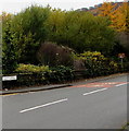
5
Two bend warning signs, Talywain
The two signs alongside the B4246 Lodge Road differ both in appearance and content. The nearer one depicts a left bend. The other one depicts a left bend with a small spot on the right of the bend, indicating a minor junction on the right side of the bend ahead.
Image: © Jaggery
Taken: 29 Sep 2015
0.06 miles
6
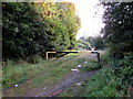
Metal barrier across a sports field entrance, Abersychan
Church Road is ahead, sports ground http://www.geograph.org.uk/photo/4681187 behind the camera.
Image: © Jaggery
Taken: 29 Sep 2015
0.06 miles
7
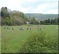
Combined football and rugby pitch, Abersychan
Located between Lodge Road and Church Road.
The scarcity of level land in this area (and elsewhere in hilly areas of South Wales) is solved by having a combined football and rugby pitch. Standard rugby posts with the crossbar 10 feet above the ground have an additional crossbar set at football level, 8 feet above the ground.
A junior football game is in progress, being played, not end-to-end, but across the pitch, using smaller than standard-sized goalposts.
Image: © Jaggery
Taken: 16 Apr 2011
0.06 miles
8
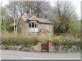
Tumbledown house, Abersychan
Evidently long abandoned, Haul-y-mynydd on Church Road is in a dangerous state of dilapidation. Out of shot, signs warn that the site is unsafe.
Image: © Jaggery
Taken: 16 Apr 2011
0.06 miles
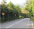
9
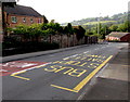
Church Road stop for northbound buses, Talywain
The stop is on the B4246 Church Road, on its long ascent from Abersychan to Blaenavon.
Image: © Jaggery
Taken: 29 Sep 2015
0.06 miles
10
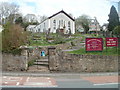
Noddfa Baptist Church, Abersychan
The church, built in 1846, is set back from the north side of Church Road.
Noddfa is Welsh for a place of refuge, a sanctuary.
Image: © Jaggery
Taken: 16 Apr 2011
0.07 miles