IMAGES TAKEN NEAR TO
Manor Road, PONTYPOOL, NP4 7DZ
Introduction
This page details the photographs taken nearby to Manor Road, NP4 7DZ by members of the Geograph project.
The Geograph project started in 2005 with the aim of publishing, organising and preserving representative images for every square kilometre of Great Britain, Ireland and the Isle of Man.

There are currently over 7.5m images from over14,400 individuals and you can help contribute to the project by visiting https://www.geograph.org.uk
Image Map
Images are licensed for reuse under creativecommons.org/licenses/by-sa/2.0
Notes
- Clicking on the map will re-center to the selected point.
- The higher the marker number, the further away the image location is from the centre of the postcode.
Image Listing (113 Images Found)
Images are licensed for reuse under creativecommons.org/licenses/by-sa/2.0
Image
Details
Distance
1
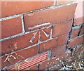
Ordnance Survey Cut Mark
This OS cut mark can be found on Delfryn, Old Lane. It marks a point 209.072m above mean sea level.
Image: © Adrian Dust
Taken: 25 Aug 2019
0.02 miles
3
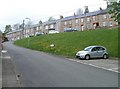
Abersychan : Manor Road houses viewed from Lewis Street
Image: © Jaggery
Taken: 16 Apr 2011
0.06 miles
4
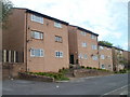
Flats on the north side of Swan Square, Abersychan
Viewed from a right-angled bend in the road. The flats in this section of the square are distinctly different from those on the south side. http://www.geograph.org.uk/photo/2376826
Image: © Jaggery
Taken: 16 Apr 2011
0.06 miles
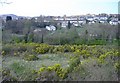
5
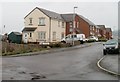
Brynamlwg, Talywain
Recently-built houses on Brynamlwg (leading to Fairfield), viewed across Waterloo Road.
Image: © Jaggery
Taken: 13 Apr 2011
0.07 miles
6
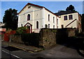
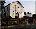
Southeast side of High Street Baptist Church, Abersychan
The nameboard on the left shows High Street Baptist Church.
The inscription on the tablet high above the entrance shows
HIGH STREET BAPTIST CHAPEL 1827.
Image: © Jaggery
Taken: 29 Sep 2015
0.08 miles
7
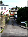
This way to Gelli Place and Rose Villas, Abersychan
Lane on the north side of High Street.
Image: © Jaggery
Taken: 29 Sep 2015
0.08 miles
8
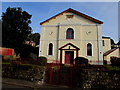
High Street Baptist Church, Abersychan
On the north side of High Street. The nameboard on the left shows High Street Baptist Church.
The inscription on the tablet high above the entrance shows
HIGH STREET BAPTIST CHAPEL 1827.
Image: © Jaggery
Taken: 29 Sep 2015
0.08 miles
9
Southwest side of High Street Baptist Church, Abersychan
The nameboard on the left shows High Street Baptist Church.
The inscription on the tablet high above the entrance shows
HIGH STREET BAPTIST CHAPEL 1827.
Image: © Jaggery
Taken: 29 Sep 2015
0.08 miles
10
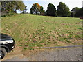
Bank near High Street, Abersychan
Grass bank ascending from Church Road towards trees at the edge of Manor Road.
The western end of High Street is nearby, out of shot on the right.
Image: © Jaggery
Taken: 29 Sep 2015
0.09 miles