IMAGES TAKEN NEAR TO
Pleasant View, Waterloo Road, PONTYPOOL, NP4 7DU
Introduction
This page details the photographs taken nearby to Pleasant View, Waterloo Road, NP4 7DU by members of the Geograph project.
The Geograph project started in 2005 with the aim of publishing, organising and preserving representative images for every square kilometre of Great Britain, Ireland and the Isle of Man.

There are currently over 7.5m images from over14,400 individuals and you can help contribute to the project by visiting https://www.geograph.org.uk
Image Map
Images are licensed for reuse under creativecommons.org/licenses/by-sa/2.0
Notes
- Clicking on the map will re-center to the selected point.
- The higher the marker number, the further away the image location is from the centre of the postcode.
Image Listing (102 Images Found)
Images are licensed for reuse under creativecommons.org/licenses/by-sa/2.0
Image
Details
Distance
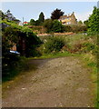
1
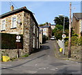
Waterloo Road, Abersychan
Ascending from the corner of Manor Road and Manor Way. The signs show no motor vehicles except for access.
Image: © Jaggery
Taken: 29 Sep 2015
0.01 miles
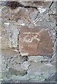
2
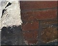
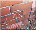
Ordnance Survey Cut Mark
This OS cut mark can be found on No1 Pleasant View. It marks a point 236.281m above mean sea level.
Image: © Adrian Dust
Taken: 25 Aug 2019
0.01 miles
3
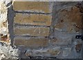
Ordnance Survey Cut Mark
This OS cut mark can be found on No123 Manor Road. It marks a point 225.247m above mean sea level.
Image: © Adrian Dust
Taken: 25 Aug 2019
0.04 miles
4
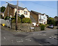
Manor Way houses, Abersychan
At the southern end of Manor Way, on the corner of Waterloo Road.
Image: © Jaggery
Taken: 29 Sep 2015
0.04 miles
5
Waterloo Road house above a fenced-off hillside, Abersychan
Viewed from Manor Way.
Image: © Jaggery
Taken: 29 Sep 2015
0.05 miles
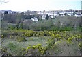
7
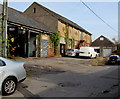
Manor Way businesses, Abersychan
Names in view in September 2015 are Up & Under Travel on the left and Gwent Fabweld behind the white van.
Image: © Jaggery
Taken: 29 Sep 2015
0.07 miles
8
Ordnance Survey Cut Mark
This OS cut mark can be found on the wall of No11 Waterloo Road. It marks a point 217.551m above mean sea level.
Image: © Adrian Dust
Taken: 25 Aug 2019
0.07 miles
9
Ordnance Survey Cut Mark
This OS cut mark can be found on Delfryn, Old Lane. It marks a point 209.072m above mean sea level.
Image: © Adrian Dust
Taken: 25 Aug 2019
0.07 miles
10
Inwardly sloping barrier across Glansychan Lane, Abersychan
Viewed from Old Lane. The blue label on the side of the barrier shows
Manufactured by FEARN TRUCK BODIES LTD Rotherham S. Yorks.
Image: © Jaggery
Taken: 29 Sep 2015
0.08 miles