IMAGES TAKEN NEAR TO
Old Lane, PONTYPOOL, NP4 7DG
Introduction
This page details the photographs taken nearby to Old Lane, NP4 7DG by members of the Geograph project.
The Geograph project started in 2005 with the aim of publishing, organising and preserving representative images for every square kilometre of Great Britain, Ireland and the Isle of Man.

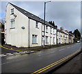
There are currently over 7.5m images from over14,400 individuals and you can help contribute to the project by visiting https://www.geograph.org.uk
Image Map
Images are licensed for reuse under creativecommons.org/licenses/by-sa/2.0
Notes
- Clicking on the map will re-center to the selected point.
- The higher the marker number, the further away the image location is from the centre of the postcode.
Image Listing (226 Images Found)
Images are licensed for reuse under creativecommons.org/licenses/by-sa/2.0
Image
Details
Distance
1
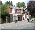
The Basement, Abersychan
Located at the junction of Ffrwd Road and Station Street (A4043). The business sells electrical toys and accessories.
Image: © Jaggery
Taken: 9 May 2011
0.00 miles
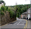
2
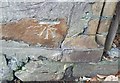
Ordnance Survey Cut Mark
This OS cut mark can be found on the wall SW side of Old Lane. It marks a point 193.252m above mean sea level.
Image: © Adrian Dust
Taken: 25 Aug 2019
0.03 miles
3
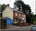
High Street semis, Abersychan
Semi-detached houses on the descent towards Broad Street.
Image: © Jaggery
Taken: 16 Jul 2018
0.04 miles
4
Up High Street, Abersychan
High Street ascends away from Broad Street, past speed bumps.
Image: © Jaggery
Taken: 16 Jul 2018
0.04 miles
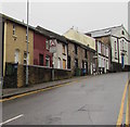
5
Station Street houses, Abersychan
Extending for 50 metres along the west side of the A4043 Station Street. The Old Lane junction is on the left.
Image: © Jaggery
Taken: 15 Mar 2018
0.04 miles
6
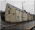
Station Street houses, Abersychan
On the west side of the A4043 Station Street. The Old Lane junction is on the left.
Image: © Jaggery
Taken: 12 Dec 2019
0.04 miles
7
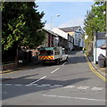
Bron Afon lorry ascends High Street, Abersychan
Bron Afon is a housing association in Torfaen. Its head office
is in William Brown Close, Llantarnam Industrial Park, Cwmbran http://www.geograph.org.uk/photo/2610857
Image: © Jaggery
Taken: 29 Sep 2015
0.04 miles
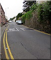
8
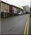
Steep High Street, Abersychan
High Street ascends from the west side of Broad Street.
Double yellow lines on both sides of High Street indicate no parking at any time.
Image: © Jaggery
Taken: 15 Mar 2018
0.04 miles
9
Speed bumps and double yellow lines, High Street, Abersychan
On the steep descent to Broad Street, double yellow lines
on both sides of High Street indicate no parking at any time.
Image: © Jaggery
Taken: 16 Jul 2018
0.04 miles
10
Steep ascent, High Street, Abersychan
Looking west up High Street from the corner of the A4043 Broad Street.
Double yellow lines on both sides of High Street indicate no parking at any time.
Image: © Jaggery
Taken: 12 Dec 2019
0.04 miles