IMAGES TAKEN NEAR TO
Club Row, Snatchwood Road, PONTYPOOL, NP4 7BZ
Introduction
This page details the photographs taken nearby to Club Row, Snatchwood Road, NP4 7BZ by members of the Geograph project.
The Geograph project started in 2005 with the aim of publishing, organising and preserving representative images for every square kilometre of Great Britain, Ireland and the Isle of Man.

There are currently over 7.5m images from over14,400 individuals and you can help contribute to the project by visiting https://www.geograph.org.uk
Image Map
Images are licensed for reuse under creativecommons.org/licenses/by-sa/2.0
Notes
- Clicking on the map will re-center to the selected point.
- The higher the marker number, the further away the image location is from the centre of the postcode.
Image Listing (87 Images Found)
Images are licensed for reuse under creativecommons.org/licenses/by-sa/2.0
Image
Details
Distance
1
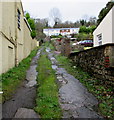
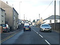
Unnamed lane, Snatchwood, Abersychan
Ascending from the west side of the A4043 Snatchwood Road towards the southern end of Club Row.
Image: © Jaggery
Taken: 17 Dec 2015
0.03 miles
2
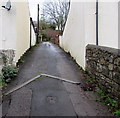
Club Row, Snatchwood, Abersychan
Ascending from the west side of the A4043 Snatchwood Road towards Oaks Road.
Image: © Jaggery
Taken: 17 Dec 2015
0.04 miles
3
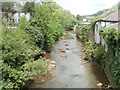
Afon Lwyd flows towards a footbridge, Pontnewynydd
The footbridge http://www.geograph.org.uk/photo/2401531 is a few metres west of the B4246 at the point where the B road's name changes from Limekiln Road to Freeholdland Road, opposite the turning for Lower Leigh Road.
Image: © Jaggery
Taken: 9 May 2011
0.05 miles
4
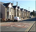
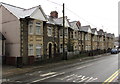
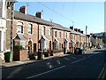
Row of unnumbered houses, Snatchwood Road, Abersychan
Along Snatchwood Road's roughly 600 metre length, many houses are numbered, but many others are not, distinguished only by a name. This occurs in several sections, and on each side of the road, so finding a particular named house can be difficult for visitors. This row of houses are all without house numbers, as are another adjacent row of houses of a different design. http://www.geograph.org.uk/photo/2138618
Image: © Jaggery
Taken: 25 Oct 2010
0.05 miles
5
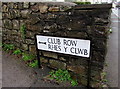
Bilingual Club Row/Rhes y Clwb sign, Snatchwood, Abersychan
The black arrow on the sign on the corner of the A4043 Snatchwood Road points left along Club Row. http://www.geograph.org.uk/photo/4767973
The English and Welsh names here are equivalents.
This is not always the case on bilingual signs, as shown by this example http://www.geograph.org.uk/photo/4191428 in Caerphilly.
Image: © Jaggery
Taken: 17 Dec 2015
0.05 miles
6
Warning sign - no footway for 100 yards, Snatchwood, Abersychan
The red-edged triangular sign faces vehicles travelling south on the A4043 Snatchwood Road.
Image: © Jaggery
Taken: 17 Dec 2015
0.05 miles
8
Nine gables, Snatchwood Road, Abersychan
Nine gables on a row of houses extending for 50 metres along the east side of the A4043 Snatchwood Road.
Image: © Jaggery
Taken: 17 Dec 2015
0.06 miles
9
Unnumbered houses, Snatchwood Road, Abersychan
Along Snatchwood Road's roughly 600 metre length, many houses are numbered, but many others are not, distinguished only by a name. This occurs in several sections, and on each side of the road, so finding a particular named house can be difficult for visitors.
This row of houses are all without house numbers, as are several houses directly opposite. In the distance, the next row of houses, http://www.geograph.org.uk/photo/2138634 of a different design, are also unnumbered.
Image: © Jaggery
Taken: 25 Oct 2010
0.06 miles
10
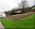
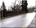
Unmown area for bees above Snatchwood Road, Abersychan
Viewed in mid December 2015. This unmown area on the west side of the A4043 Snatchwood Road contained many flowers the previous summer. A small sign at the edge of the area depicts a stylised bee.
There is a similar unmown area http://www.geograph.org.uk/photo/4767307 alongside Snatchwood Road about 250 metres behind the camera.
Image: © Jaggery
Taken: 17 Dec 2015
0.07 miles