IMAGES TAKEN NEAR TO
Snatchwood Road, PONTYPOOL, NP4 7BX
Introduction
This page details the photographs taken nearby to Snatchwood Road, NP4 7BX by members of the Geograph project.
The Geograph project started in 2005 with the aim of publishing, organising and preserving representative images for every square kilometre of Great Britain, Ireland and the Isle of Man.

There are currently over 7.5m images from over14,400 individuals and you can help contribute to the project by visiting https://www.geograph.org.uk
Image Map
Images are licensed for reuse under creativecommons.org/licenses/by-sa/2.0
Notes
- Clicking on the map will re-center to the selected point.
- The higher the marker number, the further away the image location is from the centre of the postcode.
Image Listing (134 Images Found)
Images are licensed for reuse under creativecommons.org/licenses/by-sa/2.0
Image
Details
Distance
1
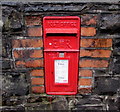
Queen Elizabeth II postbox in a Snatchwood wall, Abersychan
Bricks surround the box in a stone wall on the west side of the A4043 Snatchwood Road. http://www.geograph.org.uk/photo/4767955
Image: © Jaggery
Taken: 17 Dec 2015
0.00 miles
2
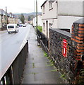
Postbox in a Snatchwood wall, Abersychan
Facing an elevated pavement, the box is 20th century (or possibly early 21st century) Elizabethan. http://www.geograph.org.uk/photo/4767950
Image: © Jaggery
Taken: 17 Dec 2015
0.00 miles
3
Down an elevated pavement, Snatchwood, Abersychan
The pavement on the west side of the A4043 Snatchwood Road descends to road level.
Image: © Jaggery
Taken: 17 Dec 2015
0.01 miles
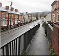
4
Elevated pavement above Snatchwood Road, Abersychan
For 30 metres, the pavement on the west side of the A4043 Snatchwood Road is above street level.
Image: © Jaggery
Taken: 17 Dec 2015
0.01 miles
5
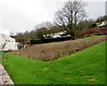
Unmown area for bees above Snatchwood Road, Abersychan
Viewed in mid December 2015. This unmown area on the west side of the A4043 Snatchwood Road contained many flowers the previous summer. A small sign at the edge of the area depicts a stylised bee.
There is a similar unmown area http://www.geograph.org.uk/photo/4767307 alongside Snatchwood Road about 250 metres behind the camera.
Image: © Jaggery
Taken: 17 Dec 2015
0.02 miles
6
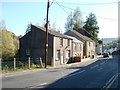
Owendale Terrace houses, Snatchwood, Abersychan
On the south side of Snatchwood Terrace.
Image: © Jaggery
Taken: 17 Dec 2015
0.02 miles
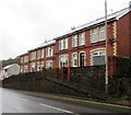
7
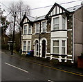
Rossmoyne and Rhoswen, Snatchwood, Abersychan
Semi-detached houses on the east side of the A4043 Snatchwood Road.
Image: © Jaggery
Taken: 17 Dec 2015
0.03 miles
8
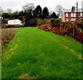
Buildings above Snatchwood Road, Abersychan
A grass strip west from Snatchwood Road ascends towards the southern end of Owendale Terrace.
Image: © Jaggery
Taken: 17 Dec 2015
0.03 miles
9
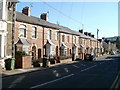
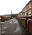
Unnumbered houses, Snatchwood Road, Abersychan
Along Snatchwood Road's roughly 600 metre length, many houses are numbered, but many others are not, distinguished only by a name. This occurs in several sections, and on each side of the road, so finding a particular named house can be difficult for visitors.
This row of houses are all without house numbers, as are several houses directly opposite. In the distance, the next row of houses, http://www.geograph.org.uk/photo/2138634 of a different design, are also unnumbered.
Image: © Jaggery
Taken: 25 Oct 2010
0.03 miles
10
House numbering oddity, Snatchwood Road, Abersychan
These three houses on Snatchwood Road, opposite Snatchwood Terrace are numbered
21,22 and 28.
Image: © Jaggery
Taken: 25 Oct 2010
0.03 miles