IMAGES TAKEN NEAR TO
Gelli Place, PONTYPOOL, NP4 7AJ
Introduction
This page details the photographs taken nearby to Gelli Place, NP4 7AJ by members of the Geograph project.
The Geograph project started in 2005 with the aim of publishing, organising and preserving representative images for every square kilometre of Great Britain, Ireland and the Isle of Man.

There are currently over 7.5m images from over14,400 individuals and you can help contribute to the project by visiting https://www.geograph.org.uk
Image Map
Images are licensed for reuse under creativecommons.org/licenses/by-sa/2.0
Notes
- Clicking on the map will re-center to the selected point.
- The higher the marker number, the further away the image location is from the centre of the postcode.
Image Listing (126 Images Found)
Images are licensed for reuse under creativecommons.org/licenses/by-sa/2.0
Image
Details
Distance
1
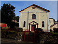
High Street Baptist Church, Abersychan
On the north side of High Street. The nameboard on the left shows High Street Baptist Church.
The inscription on the tablet high above the entrance shows
HIGH STREET BAPTIST CHAPEL 1827.
Image: © Jaggery
Taken: 29 Sep 2015
0.01 miles
2
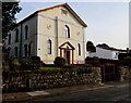
Southwest side of High Street Baptist Church, Abersychan
The nameboard on the left shows High Street Baptist Church.
The inscription on the tablet high above the entrance shows
HIGH STREET BAPTIST CHAPEL 1827.
Image: © Jaggery
Taken: 29 Sep 2015
0.01 miles
3
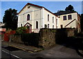
Southeast side of High Street Baptist Church, Abersychan
The nameboard on the left shows High Street Baptist Church.
The inscription on the tablet high above the entrance shows
HIGH STREET BAPTIST CHAPEL 1827.
Image: © Jaggery
Taken: 29 Sep 2015
0.02 miles
4
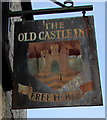
Old Castle Inn name sign, High Street, Abersychan
Hanging from a wall bracket here. http://www.geograph.org.uk/photo/4681281
The original red blue and green colours on the sign have been replaced by rust.
Image: © Jaggery
Taken: 29 Sep 2015
0.02 miles
5
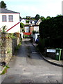
This way to Gelli Place and Rose Villas, Abersychan
Lane on the north side of High Street.
Image: © Jaggery
Taken: 29 Sep 2015
0.02 miles
6
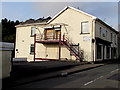
Fire-damaged former Pulse Fitness Centre, High Street, Abersychan
Satellite imagery shows extensive damage to the roof of this building, caused by a fire in October 2012.
This late September 2015 view shows a part of the damaged roof on the left.
Image: © Jaggery
Taken: 29 Sep 2015
0.03 miles
7
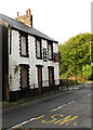
Derelict former Old Castle Inn, Abersychan
Viewed across High Street in late September 2015.
Image: © Jaggery
Taken: 29 Sep 2015
0.03 miles
8
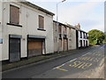
Dereliction in High Street, Abersychan
Urban renewal has not yet arrived in this High Street, viewed in late September 2015.
Another long derelict part of High Street www.geograph.org.uk/photo/4681212 is nearby.
Image: © Jaggery
Taken: 29 Sep 2015
0.03 miles
9
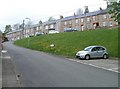
Abersychan : Manor Road houses viewed from Lewis Street
Image: © Jaggery
Taken: 16 Apr 2011
0.03 miles
10
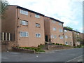
Flats on the north side of Swan Square, Abersychan
Viewed from a right-angled bend in the road. The flats in this section of the square are distinctly different from those on the south side. http://www.geograph.org.uk/photo/2376826
Image: © Jaggery
Taken: 16 Apr 2011
0.03 miles