IMAGES TAKEN NEAR TO
Pontnewynydd, PONTYPOOL, NP4 6UF
Introduction
This page details the photographs taken nearby to NP4 6UF by members of the Geograph project.
The Geograph project started in 2005 with the aim of publishing, organising and preserving representative images for every square kilometre of Great Britain, Ireland and the Isle of Man.

There are currently over 7.5m images from over14,400 individuals and you can help contribute to the project by visiting https://www.geograph.org.uk
Image Map
Images are licensed for reuse under creativecommons.org/licenses/by-sa/2.0
Notes
- Clicking on the map will re-center to the selected point.
- The higher the marker number, the further away the image location is from the centre of the postcode.
Image Listing (18 Images Found)
Images are licensed for reuse under creativecommons.org/licenses/by-sa/2.0
Image
Details
Distance
1
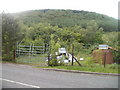
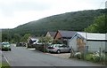
Fenced off rubbish area, Plasycoed, Pontypool
Piles of junk and some dilapidated single-storey buildings are in a fenced-off area on the north side of Plasycoed Road. A faded sign on a building shows
PAINTING DECORATING & GENERAL BUILDING. The name at the top of the sign is no longer legible.
Image: © Jaggery
Taken: 26 May 2011
0.03 miles
2
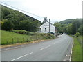
Plasycoed Road approaches Plas-y-coed Guest House, Cwm Ffrwd-oer, Pontypool
The side of the building shows both the Welsh form Plas-y-coed and the (slightly) anglicised form Plasycoed. The guest house has four en-suite rooms and a licensed restaurant.
Image: © Jaggery
Taken: 26 May 2011
0.08 miles
3
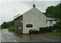
Plas-y-Coed Bed & Breakfast on Plasycoed Road
Image: © Ian S
Taken: 24 May 2014
0.08 miles
4
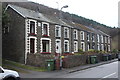
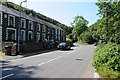
Wesley Terrace, Plasycoed Road
Row of well maintained stone cottages on a minor road, with various recycling and rubbish bins on the pavement.
Image: © M J Roscoe
Taken: 5 Dec 2017
0.10 miles
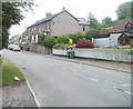
5
Wesley Terrace, Plasycoed Road
Wesley Terrace is a short row of houses on Plasycoed Road above Pontypool.
Image: © Philip Halling
Taken: 10 Aug 2012
0.10 miles
6
Plasycoed Road houses, Pontypool
Houses on the south side of the road in the hamlet of Plasycoed, SW Pontypool.
Image: © Jaggery
Taken: 26 May 2011
0.11 miles
7
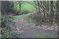
Farm track from Plasycoed Road
A track going down to a bridge over the Nant Ffrwd-oer to fields. The railings on the left are on an overgrown footbridge Image
Image: © M J Roscoe
Taken: 5 Dec 2017
0.12 miles
8
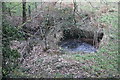
Overgrown footbridge, Nant Ffrwd-oer, Plas-y-coed
Bridge below Plasycoed Road; the bridge does not appear to on a public footpath. To the right, the stream goes into a culvert carrying a farm track Image from the road.
Image: © M J Roscoe
Taken: 5 Dec 2017
0.12 miles
9
Lockup garages and wooded hillside, Plasycoed, Pontypool
Looking past lockup garages at the SE edge of the hamlet of Plasycoed, towards a wooded hillside (Graig Ddu).
Image: © Jaggery
Taken: 26 May 2011
0.15 miles
10
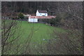
Cwm Ffrwd-oer Farm
A hillside farm on Ty-Bwmpyn Road - white farmhouse and some outbuildings - on a damp day.
Image: © M J Roscoe
Taken: 5 Dec 2017
0.16 miles