IMAGES TAKEN NEAR TO
Plasycoed, Pontnewynydd, PONTYPOOL, NP4 6UE
Introduction
This page details the photographs taken nearby to NP4 6UE by members of the Geograph project.
The Geograph project started in 2005 with the aim of publishing, organising and preserving representative images for every square kilometre of Great Britain, Ireland and the Isle of Man.

There are currently over 7.5m images from over14,400 individuals and you can help contribute to the project by visiting https://www.geograph.org.uk
Image Map
Images are licensed for reuse under creativecommons.org/licenses/by-sa/2.0
Notes
- Clicking on the map will re-center to the selected point.
- The higher the marker number, the further away the image location is from the centre of the postcode.
Image Listing (9 Images Found)
Images are licensed for reuse under creativecommons.org/licenses/by-sa/2.0
Image
Details
Distance
1
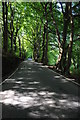
Road through Coed Parciau
Country road passing beech trees in Coed Parciau.
Image: © Philip Halling
Taken: 10 Aug 2012
0.07 miles
2
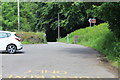
Car park, Tirpentwys LNR
Entrance from Pantygasseg Road to nature reserve car park (brown sign on right). The path into the reserve is behind the camera; hoof marks are evident!
Image: © M J Roscoe
Taken: 13 Jun 2017
0.10 miles
3
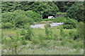
Pasture above car park, Tirpentwys LNR
The pasture, on a reclaimed tip, slopes up from the car park Image; the white van is on Pantygasseg Road alongside Coed Parciau.
Image: © M J Roscoe
Taken: 13 Jun 2017
0.11 miles
4
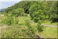
Path in Tirpentwys Local Nature Reserve
Path down to the reserve's car park Image from footbridge over the stream. The trees in the background are on the edge of Coed Parciau.
Image: © M J Roscoe
Taken: 13 Jun 2017
0.13 miles
5
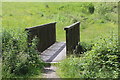
Footbridge in Tirpentwys Local Nature Reserve
Bridge over Nant Ffrwd-oer Image to hillside pasture on reclaimed tip.
Image: © M J Roscoe
Taken: 13 Jun 2017
0.17 miles
6
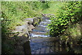
Nant Ffrwd-oer, Tirpentwys LNR
Realigned stream on a reclaimed tip in a local nature reserve on reclaimed land in Cwm Ffrwd-oer; looking downstream from under a footbridge Image
Image: © M J Roscoe
Taken: 13 Jun 2017
0.17 miles
7
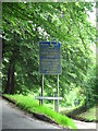
Sign by road down to Abergelli Cottages
The road on the left of this picture is flanked by ancient beech trees which have once been part of a hedge, so the trunks are strange shapes. The road to the right leads down to a narrow twisty lane, over a small bridge, past Abergelli Cottages into Ty-bwmpyn road. This very narrow and runs between high banks.
Image: © Jessica Aidley
Taken: 6 Jul 2007
0.18 miles
8
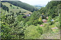
Tirpentwys LNR
The north eastern section of the nature reserve on reclaimed colliery land in Cwm frwd-oer; the grass slope in the background is reclaimed colliery waste and is the northern limit of the reserve. The buildings at its base are part of Plasycoed Farm. The woodland on the right is the edge of Coed Parciau.
Image: © M J Roscoe
Taken: 13 Jun 2017
0.18 miles
9
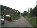
Abergelli Cottages
A tiny hamlet in a valley near a bridge.
Image: © Jessica Aidley
Taken: 6 Jul 2007
0.22 miles