IMAGES TAKEN NEAR TO
Limekiln Road, PONTYPOOL, NP4 6TE
Introduction
This page details the photographs taken nearby to Limekiln Road, NP4 6TE by members of the Geograph project.
The Geograph project started in 2005 with the aim of publishing, organising and preserving representative images for every square kilometre of Great Britain, Ireland and the Isle of Man.

There are currently over 7.5m images from over14,400 individuals and you can help contribute to the project by visiting https://www.geograph.org.uk
Image Map
Images are licensed for reuse under creativecommons.org/licenses/by-sa/2.0
Notes
- Clicking on the map will re-center to the selected point.
- The higher the marker number, the further away the image location is from the centre of the postcode.
Image Listing (91 Images Found)
Images are licensed for reuse under creativecommons.org/licenses/by-sa/2.0
Image
Details
Distance
1
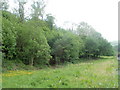
Woodland bordering Limekiln Road, Pontnewynydd
Along most of Limekiln Road, there are houses on the west side of the road only. The east side is the edge of woodland.
Image: © Jaggery
Taken: 9 May 2011
0.01 miles
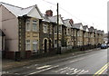
2
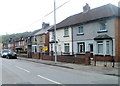
Limekiln Road houses, Pontnewynydd
Houses on the west side of the road, woodland http://www.geograph.org.uk/photo/2401214 on the east. The houses have names not numbers.
Image: © Jaggery
Taken: 9 May 2011
0.01 miles
3
Redevelopment of Pleasant Court, Abersychan (2)
Refurbishment and redevelopment work is in progress. This is a view of the southern section of Pleasant Court, Limekiln Road. http://www.geograph.org.uk/photo/2401011 to the northern section.
Image: © Jaggery
Taken: 9 May 2011
0.06 miles
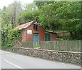
4
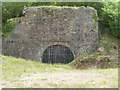
Disused lime kiln, Limekiln Road, Pontnewynydd
A metal grid blocks the entrance of a disused lime kiln on the east side of Limekiln Road.
Image: © Jaggery
Taken: 9 May 2011
0.06 miles
5
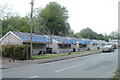
Nine gables, Snatchwood Road, Abersychan
Nine gables on a row of houses extending for 50 metres along the east side of the A4043 Snatchwood Road.
Image: © Jaggery
Taken: 17 Dec 2015
0.07 miles
6
The Old Pump House, Pontnewynydd
Premises of West End Building Contractors, Limekiln Road.
Image: © Jaggery
Taken: 9 May 2011
0.07 miles
7
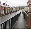
Down an elevated pavement, Snatchwood, Abersychan
The pavement on the west side of the A4043 Snatchwood Road descends to road level.
Image: © Jaggery
Taken: 17 Dec 2015
0.07 miles
8
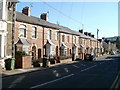
Unnumbered houses, Snatchwood Road, Abersychan
Along Snatchwood Road's roughly 600 metre length, many houses are numbered, but many others are not, distinguished only by a name. This occurs in several sections, and on each side of the road, so finding a particular named house can be difficult for visitors.
This row of houses are all without house numbers, as are several houses directly opposite. In the distance, the next row of houses, http://www.geograph.org.uk/photo/2138634 of a different design, are also unnumbered.
Image: © Jaggery
Taken: 25 Oct 2010
0.07 miles
9
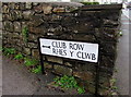
Bilingual Club Row/Rhes y Clwb sign, Snatchwood, Abersychan
The black arrow on the sign on the corner of the A4043 Snatchwood Road points left along Club Row. http://www.geograph.org.uk/photo/4767973
The English and Welsh names here are equivalents.
This is not always the case on bilingual signs, as shown by this example http://www.geograph.org.uk/photo/4191428 in Caerphilly.
Image: © Jaggery
Taken: 17 Dec 2015
0.07 miles
10
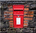
Queen Elizabeth II postbox in a Snatchwood wall, Abersychan
Bricks surround the box in a stone wall on the west side of the A4043 Snatchwood Road. http://www.geograph.org.uk/photo/4767955
Image: © Jaggery
Taken: 17 Dec 2015
0.07 miles