IMAGES TAKEN NEAR TO
St. Lukes Road, PONTYPOOL, NP4 6SU
Introduction
This page details the photographs taken nearby to St. Lukes Road, NP4 6SU by members of the Geograph project.
The Geograph project started in 2005 with the aim of publishing, organising and preserving representative images for every square kilometre of Great Britain, Ireland and the Isle of Man.

There are currently over 7.5m images from over14,400 individuals and you can help contribute to the project by visiting https://www.geograph.org.uk
Image Map
Images are licensed for reuse under creativecommons.org/licenses/by-sa/2.0
Notes
- Clicking on the map will re-center to the selected point.
- The higher the marker number, the further away the image location is from the centre of the postcode.
Image Listing (218 Images Found)
Images are licensed for reuse under creativecommons.org/licenses/by-sa/2.0
Image
Details
Distance
1
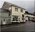
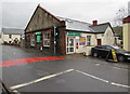
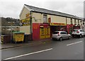
Treasure House, Pontnewynydd
Chinese takeaway in an area of shops on both sides of the A4043 St Lukes Road.
A Premier convenience store is on the right. http://www.geograph.org.uk/photo/4770580
Image: © Jaggery
Taken: 17 Dec 2015
0.00 miles
3
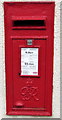
King George VI postbox in a Pontnewynydd wall
Located here http://www.geograph.org.uk/photo/4770633 in the wall of a former post office building.
Image: © Jaggery
Taken: 17 Dec 2015
0.01 miles
4
Premier convenience store, Pontnewynydd
Text on the wall of the store at 8 St Lukes Road shows News & Magazines, Fruit & Vegetables, Off Licence, Lotto.
Image: © Jaggery
Taken: 17 Dec 2015
0.01 miles
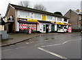
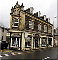
5
Health Plus Pharmacy, Pontnewynydd
Located at 2 St Luke's Road in a former post office building.
The red postbox http://www.geograph.org.uk/photo/4770640 in the wall is a reminder of that former usage.
Image: © Jaggery
Taken: 17 Dec 2015
0.01 miles
6
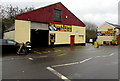
Sam's Tyres, Pontnewynydd
The St Lukes Road business sells new and part-worn tyres and provides a vehicle wheel alignment service.
Image: © Jaggery
Taken: 17 Dec 2015
0.01 miles
7
Cream in Pontnewynydd
Cream Hair Design Unisex Hair Salon is at 1 St Luke's Road, on the corner of Pentrepiod Road.
Image: © Jaggery
Taken: 17 Dec 2015
0.02 miles
8
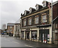
Former pharmacy to let in Pontnewynydd
Viewed across the A4043 St Luke's Road in December 2015 when a To Let board on the pavement on the right rests against a former pharmacy. Next door, Cream Hair Design Unisex Hair Salon at 1 St Luke's Road is on the corner of Pentrepiod Road. http://www.geograph.org.uk/photo/4770654
Image: © Jaggery
Taken: 17 Dec 2015
0.02 miles
9
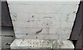
Ordnance Survey Cut Mark
This OS cut mark can be found on No1 Lukes Road. It marks a point 150.739m above mean sea level.
Image: © Adrian Dust
Taken: 16 Feb 2021
0.02 miles
10
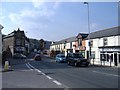
Marmaris Kebab House, Pontnewynydd
Kebab & pizza takeaway in an area of shops on both sides of the A4043 St Lukes Road.
Image: © Jaggery
Taken: 17 Dec 2015
0.02 miles