IMAGES TAKEN NEAR TO
Caepalish, PONTYPOOL, NP4 6ST
Introduction
This page details the photographs taken nearby to Caepalish, NP4 6ST by members of the Geograph project.
The Geograph project started in 2005 with the aim of publishing, organising and preserving representative images for every square kilometre of Great Britain, Ireland and the Isle of Man.

There are currently over 7.5m images from over14,400 individuals and you can help contribute to the project by visiting https://www.geograph.org.uk
Image Map
Images are licensed for reuse under creativecommons.org/licenses/by-sa/2.0
Notes
- Clicking on the map will re-center to the selected point.
- The higher the marker number, the further away the image location is from the centre of the postcode.
Image Listing (222 Images Found)
Images are licensed for reuse under creativecommons.org/licenses/by-sa/2.0
Image
Details
Distance
1
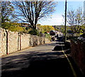
Down Pentrepiod Road, Pontnewynydd
Pentrepiod Road descends towards the A4043.
Image: © Jaggery
Taken: 2 Nov 2018
0.02 miles
2
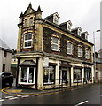
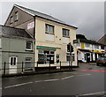
Cream in Pontnewynydd
Cream Hair Design Unisex Hair Salon is at 1 St Luke's Road, on the corner of Pentrepiod Road.
Image: © Jaggery
Taken: 17 Dec 2015
0.02 miles
3
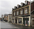
Former pharmacy to let in Pontnewynydd
Viewed across the A4043 St Luke's Road in December 2015 when a To Let board on the pavement on the right rests against a former pharmacy. Next door, Cream Hair Design Unisex Hair Salon at 1 St Luke's Road is on the corner of Pentrepiod Road. http://www.geograph.org.uk/photo/4770654
Image: © Jaggery
Taken: 17 Dec 2015
0.02 miles
4
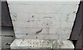
Ordnance Survey Cut Mark
This OS cut mark can be found on No1 Lukes Road. It marks a point 150.739m above mean sea level.
Image: © Adrian Dust
Taken: 16 Feb 2021
0.02 miles
5
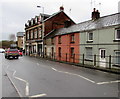
Treasure House, Pontnewynydd
Chinese takeaway in an area of shops on both sides of the A4043 St Lukes Road.
A Premier convenience store is on the right. http://www.geograph.org.uk/photo/4770580
Image: © Jaggery
Taken: 17 Dec 2015
0.02 miles
6
E.I.Peake Funeral Home, Hanbury Road, Pontnewynydd
Funeral directors at 87 Hanbury Road, near the corner of the A4043 Osborne Road (ahead).
Image: © Jaggery
Taken: 1 Sep 2016
0.02 miles
7
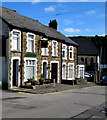
Houses, shops and railings, St Luke's Road, Pontnewynydd
Viewed across the A4043 St Luke's Road. The cars are near the Pentrepiod Road junction.
Image: © Jaggery
Taken: 17 Dec 2015
0.02 miles
8
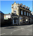
Cream in a late Victorian building, Pontnewynydd
Cream Hair Design Unisex Hair Salon is at 1 St Luke's Road,
on the corner of Pentrepiod Road. The building is dated 1894. https://www.geograph.org.uk/photo/5961924
Image: © Jaggery
Taken: 2 Nov 2018
0.02 miles
9
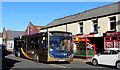
X24 bus in Pontnewynydd
The Stagecoach Gold bus on the A4043 St Luke's Road is on bus route X24 from Blaenavon to Newport.
Fleet number in view is 27286.
Image: © Jaggery
Taken: 2 Nov 2018
0.02 miles
10
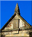
Year 1894 on a Pontnewynydd building
Faded in 2018, the year 1894 is near the top of this https://www.geograph.org.uk/photo/5961918 building.
Image: © Jaggery
Taken: 2 Nov 2018
0.02 miles