IMAGES TAKEN NEAR TO
Zion Hill, PONTYPOOL, NP4 6SA
Introduction
This page details the photographs taken nearby to Zion Hill, NP4 6SA by members of the Geograph project.
The Geograph project started in 2005 with the aim of publishing, organising and preserving representative images for every square kilometre of Great Britain, Ireland and the Isle of Man.

There are currently over 7.5m images from over14,400 individuals and you can help contribute to the project by visiting https://www.geograph.org.uk
Image Map
Images are licensed for reuse under creativecommons.org/licenses/by-sa/2.0
Notes
- Clicking on the map will re-center to the selected point.
- The higher the marker number, the further away the image location is from the centre of the postcode.
Image Listing (220 Images Found)
Images are licensed for reuse under creativecommons.org/licenses/by-sa/2.0
Image
Details
Distance
1
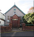
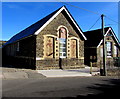
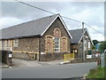
Zion Hill Baptist Chapel, Mount Pleasant, Pontnewynydd
On the south side of Pentrepiod Road, this is the 1928
rebuild/extension of the original chapel erected in 1881. https://www.geograph.org.uk/photo/5962007
Image: © Jaggery
Taken: 2 Nov 2018
0.01 miles
2
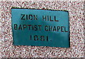
Zion Hill Baptist Chapel 1881 plaque, Mount Pleasant, Pontnewynydd
On the wall here. https://www.geograph.org.uk/photo/5962004
Image: © Jaggery
Taken: 2 Nov 2018
0.01 miles
3
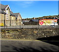
Slimming World banner on Pentrepiod Road railings, Pontnewynydd
Viewed in November 2018. The banner shows that Slimming World meets in Zion Hill Community Centre (on the left) every Wednesday at 5:30pm and 7:30pm. Zion Hill Community Centre is also known as Pontnewynydd Community Centre.
Image: © Jaggery
Taken: 2 Nov 2018
0.01 miles
4
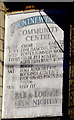
Information board on the wall of Pontnewynydd Community Centre
On the wall centre right here https://www.geograph.org.uk/photo/5962028 viewed in November 2018.
Pontnewynydd Community Centre is also known as Zion Hill Community Centre.
Image: © Jaggery
Taken: 2 Nov 2018
0.03 miles
5
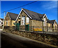
Pontnewynydd Community Centre, Pentrepiod Road, Pontnewynydd
Pontnewynydd Community Centre is also known as Zion Hill Community Centre.
Image: © Jaggery
Taken: 2 Nov 2018
0.03 miles
6
Zion Hill Community Centre, Pontnewynydd
Viewed across Pentrepiod Road. Zion Hill Community Centre is also known as Pontnewynydd Community Centre.
Image: © Jaggery
Taken: 2 Nov 2018
0.03 miles
7
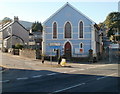
Pontnewynydd Methodist Church
Blue-painted church on the corner of Hanbury Road and Pentrepiod Road, viewed across Osborne Road (A4043). The inscription on the roundel above the central window is WESLEYAN CHAPEL 1849.
Image: © Jaggery
Taken: 25 Oct 2010
0.03 miles
8
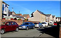
On-street parking, Mount Pleasant Road, Pontnewynydd
Looking towards Pentrepiod Road.
Image: © Jaggery
Taken: 2 Nov 2018
0.04 miles
9
Pontnewynydd Community Centre, Pontypool
Located on Pentre-piod Road.
Image: © Jaggery
Taken: 26 May 2011
0.04 miles
10
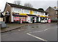
Premier convenience store, Pontnewynydd
Text on the wall of the store at 8 St Lukes Road shows News & Magazines, Fruit & Vegetables, Off Licence, Lotto.
Image: © Jaggery
Taken: 17 Dec 2015
0.05 miles