IMAGES TAKEN NEAR TO
Folly View, Pentrepiod Road, PONTYPOOL, NP4 6RY
Introduction
This page details the photographs taken nearby to Folly View, Pentrepiod Road, NP4 6RY by members of the Geograph project.
The Geograph project started in 2005 with the aim of publishing, organising and preserving representative images for every square kilometre of Great Britain, Ireland and the Isle of Man.

There are currently over 7.5m images from over14,400 individuals and you can help contribute to the project by visiting https://www.geograph.org.uk
Image Map
Images are licensed for reuse under creativecommons.org/licenses/by-sa/2.0
Notes
- Clicking on the map will re-center to the selected point.
- The higher the marker number, the further away the image location is from the centre of the postcode.
Image Listing (115 Images Found)
Images are licensed for reuse under creativecommons.org/licenses/by-sa/2.0
Image
Details
Distance
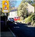
1
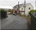
Houses at a bend in the road, Pentrepiod, Torfaen
On the south side of Pentrepiod Road.
Image: © Jaggery
Taken: 6 Nov 2018
0.00 miles
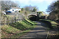
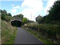
2
Road bridge over a former railway line, Pentrepiod, Torfaen
The bridge carries Pentrepiod Road over a footpath and cycleway which use the route of a dismantled railway. The remains https://www.geograph.org.uk/photo/5966538 of the former Pentrepiod Halt station, which closed in 1941, are below the right side of the bridge.
Image: © Jaggery
Taken: 6 Nov 2018
0.02 miles
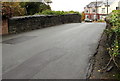
3
Up Pentrepiod Road, Pentrepiod, Torfaen
Pentrepiod Road west of the Chapel Road junction.
Signs indicate bend to the right ahead and no footway for 200 yards.
Image: © Jaggery
Taken: 6 Nov 2018
0.02 miles
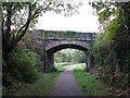
4
Pentrepiod Road bridge over cycle route
On the right of the former GWR trackbed, now NCR 492, is the stone platform of the former Pentrepiod Halt. The inclined path on the left is not shown on the OS map.
Image: © M J Roscoe
Taken: 25 Feb 2022
0.02 miles
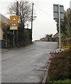
5
No footway for 200 yards, Pentrepiod Road, Pentrepiod, Torfaen
A bend in the road is ahead.
Image: © Jaggery
Taken: 2 Nov 2018
0.02 miles
6
Pentre-Piod Road bridge over NCN492 (former railway)
Image: © David Smith
Taken: 26 Sep 2021
0.02 miles
7
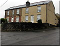
Two semis above a Pentrepiod corner, Torfaen
Semi-detached houses above the corner of Pentrepiod Road and Chapel Road.
Image: © Jaggery
Taken: 6 Nov 2018
0.03 miles
8
Bridge over former railway near Pentrepiod Halt
Image: © Gareth James
Taken: 15 Oct 2011
0.03 miles
9
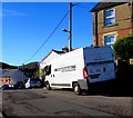
Pure Severn van, Chapel Road, Pontnewynydd
Pure Severn Provisions Ltd is based in Leeway Industrial Estate, Newport. https://www.geograph.org.uk/photo/6026260
Image: © Jaggery
Taken: 2 Nov 2018
0.03 miles
10

Warning sign - Patrol, Pentrepiod Road, Pentrepiod, Torfaen
Alongside Pentrepiod Road opposite the Chapel Lane junction. The sign text is also in Welsh.
Image: © Jaggery
Taken: 6 Nov 2018
0.03 miles