IMAGES TAKEN NEAR TO
Waunddu, PONTYPOOL, NP4 6QY
Introduction
This page details the photographs taken nearby to Waunddu, NP4 6QY by members of the Geograph project.
The Geograph project started in 2005 with the aim of publishing, organising and preserving representative images for every square kilometre of Great Britain, Ireland and the Isle of Man.

There are currently over 7.5m images from over14,400 individuals and you can help contribute to the project by visiting https://www.geograph.org.uk
Image Map
Images are licensed for reuse under creativecommons.org/licenses/by-sa/2.0
Notes
- Clicking on the map will re-center to the selected point.
- The higher the marker number, the further away the image location is from the centre of the postcode.
Image Listing (123 Images Found)
Images are licensed for reuse under creativecommons.org/licenses/by-sa/2.0
Image
Details
Distance
1
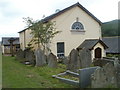
Ebenezer United Reformed Church, Pontnewynydd, Pontypool
Graveyard and church viewed from Chapel Road.
Image: © Jaggery
Taken: 26 May 2011
0.04 miles
2
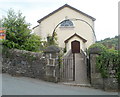
Entrance to Ebenezer United Reformed Church, Pontnewynydd, Pontypool
Viewed across Chapel Road. Ebenezer United Reformed Church was founded in 1740 by Edmund Jones. At first, meetings were held in his cottage. In 1742, to accommodate increasing numbers attending the meetings, he financed the building of this church, largely from his own life savings. The church was modified on several occasions in the 19th century.
Image: © Jaggery
Taken: 26 May 2011
0.04 miles
3
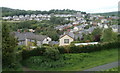
Cwm Ffrwd-oer, Pontypool
The view north towards the Cwm Ffrwd-oer district of Pontypool from the top of steps. http://www.geograph.org.uk/photo/2442182
The white houses in the distance are on a road named Waunddu, which follows a roughly triangular course.
Image: © Jaggery
Taken: 26 May 2011
0.05 miles
4
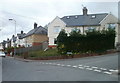
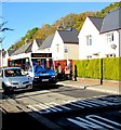
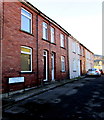
Waunddu houses, Pontypool
Houses on the southern edge of a residential street, Waunddu, following a roughly triangular course on the west side of Chapel Road.
Image: © Jaggery
Taken: 26 May 2011
0.05 miles
5
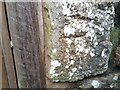
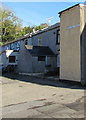
Ordnance Survey Cut Mark
This badly eroded OS cut mark can be found on the SE side of Chapel Road. It marks a point 175.833m above mean sea level.
Image: © Adrian Dust
Taken: 16 Feb 2021
0.05 miles
6
Pontypool bus in Waunddu, Pontnewynydd
The Stagecoach bus destination display shows route 16 to Market Square, Pontypool.
Image: © Jaggery
Taken: 2 Nov 2018
0.06 miles
7
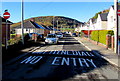
DIM MYNEDIAD/NO ENTRY on Waunddu, Pontnewynydd
Welsh/English text painted on the road surface.
Image: © Jaggery
Taken: 2 Nov 2018
0.06 miles
8
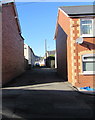
West along Waunddu, Pontnewynydd
From Church Road.
Image: © Jaggery
Taken: 2 Nov 2018
0.07 miles
9
Baileys Houses, Waunddu, Pontnewynydd
The sign on the left shows that there is no apostrophe in Baileys.
Image: © Jaggery
Taken: 2 Nov 2018
0.07 miles
10
Woodland Terrace name sign, Waunddu, Pontnewynydd
At the southern end of a row of houses.
Image: © Jaggery
Taken: 2 Nov 2018
0.07 miles