IMAGES TAKEN NEAR TO
Chapel Road, PONTYPOOL, NP4 6QR
Introduction
This page details the photographs taken nearby to Chapel Road, NP4 6QR by members of the Geograph project.
The Geograph project started in 2005 with the aim of publishing, organising and preserving representative images for every square kilometre of Great Britain, Ireland and the Isle of Man.

There are currently over 7.5m images from over14,400 individuals and you can help contribute to the project by visiting https://www.geograph.org.uk
Image Map
Images are licensed for reuse under creativecommons.org/licenses/by-sa/2.0
Notes
- Clicking on the map will re-center to the selected point.
- The higher the marker number, the further away the image location is from the centre of the postcode.
Image Listing (130 Images Found)
Images are licensed for reuse under creativecommons.org/licenses/by-sa/2.0
Image
Details
Distance
1
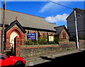
Former All Saints church for sale, Pontnewynydd
The former church building on the north side of Hanbury Road is for sale, viewed on September 1st 2016.
This http://www.geograph.org.uk/photo/2441201 is a May 2011 view of the church.
Image: © Jaggery
Taken: 1 Sep 2016
0.03 miles
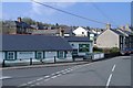
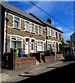
2
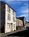
Harley House, Hanbury Road, Pontnewynydd
Three-storey detached house on the north side of Hanbury Road.
Image: © Jaggery
Taken: 1 Sep 2016
0.03 miles
3
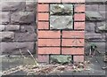
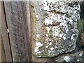
Ordnance Survey Cut Mark
This OS cut mark can be found on the front of the chapel. It marks a point 163.367m above mean sea level.
Image: © Adrian Dust
Taken: 16 Feb 2021
0.03 miles
4
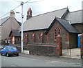
All Saints church, Pontnewynydd, Pontypool
Church in Wales church located near the western end of Hanbury Road, Pontnewynydd.
Image: © Jaggery
Taken: 26 May 2011
0.03 miles
5
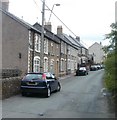
Western end of Hanbury Road, Pontnewynydd, Pontypool
Viewed from the crossroads of Estate Road, Plasycoed Road and Chapel Road.
Image: © Jaggery
Taken: 26 May 2011
0.03 miles
7
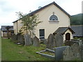
Ebenezer United Reformed Church, Pontnewynydd, Pontypool
Graveyard and church viewed from Chapel Road.
Image: © Jaggery
Taken: 26 May 2011
0.03 miles
8
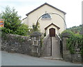
Entrance to Ebenezer United Reformed Church, Pontnewynydd, Pontypool
Viewed across Chapel Road. Ebenezer United Reformed Church was founded in 1740 by Edmund Jones. At first, meetings were held in his cottage. In 1742, to accommodate increasing numbers attending the meetings, he financed the building of this church, largely from his own life savings. The church was modified on several occasions in the 19th century.
Image: © Jaggery
Taken: 26 May 2011
0.03 miles
9
Ordnance Survey Cut Mark
This badly eroded OS cut mark can be found on the SE side of Chapel Road. It marks a point 175.833m above mean sea level.
Image: © Adrian Dust
Taken: 16 Feb 2021
0.04 miles
10
Mervyn Terrace, Hanbury Road, Pontnewynydd
One of several separately-named rows of houses in Hanbury Road.
Image: © Jaggery
Taken: 1 Sep 2016
0.04 miles