IMAGES TAKEN NEAR TO
Matthew Terrace, PONTYPOOL, NP4 6PU
Introduction
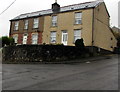
This page details the photographs taken nearby to Matthew Terrace, NP4 6PU by members of the Geograph project.
The Geograph project started in 2005 with the aim of publishing, organising and preserving representative images for every square kilometre of Great Britain, Ireland and the Isle of Man.

There are currently over 7.5m images from over14,400 individuals and you can help contribute to the project by visiting https://www.geograph.org.uk
Image Map
Images are licensed for reuse under creativecommons.org/licenses/by-sa/2.0
Notes
- Clicking on the map will re-center to the selected point.
- The higher the marker number, the further away the image location is from the centre of the postcode.
Image Listing (159 Images Found)
Images are licensed for reuse under creativecommons.org/licenses/by-sa/2.0
Image
Details
Distance
1
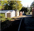
Lockup garages in Pontnewynydd
Alongside a side road east of Church Road.
Image: © Jaggery
Taken: 2 Nov 2018
0.03 miles
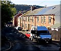
2
South along Chapel Road, Pontnewynydd
The Waunddu junction is on the right.
Image: © Jaggery
Taken: 2 Nov 2018
0.04 miles
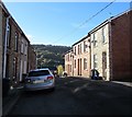
3
Sawtells Terrace, Pontnewynydd
Row of houses alongside Church Road.
Image: © Jaggery
Taken: 2 Nov 2018
0.04 miles
4
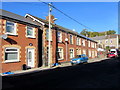
West side of Church Road, Pontnewynydd
Church Road houses north of the Waunddu junction.
Image: © Jaggery
Taken: 2 Nov 2018
0.05 miles
5
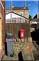
Queen Elizabeth II postbox, Church Road, Pontnewynydd
On the right here. https://www.geograph.org.uk/photo/6103525
Image: © Jaggery
Taken: 2 Nov 2018
0.05 miles
6
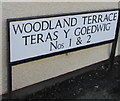
Woodland Terrace bilingual name sign, Waunddu, Pontnewynydd
Woodland Terrace is Teras y Goedwig in Welsh.
Image: © Jaggery
Taken: 2 Nov 2018
0.05 miles
7
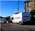
Pure Severn van, Chapel Road, Pontnewynydd
Pure Severn Provisions Ltd is based in Leeway Industrial Estate, Newport. https://www.geograph.org.uk/photo/6026260
Image: © Jaggery
Taken: 2 Nov 2018
0.06 miles
8
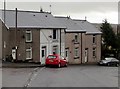
Row of four houses, Pentrepiod Road, Pentrepiod, Torfaen
The Lewis Wood junction is on the left.
Image: © Jaggery
Taken: 6 Nov 2018
0.07 miles
9
Two semis above a Pentrepiod corner, Torfaen
Semi-detached houses above the corner of Pentrepiod Road and Chapel Road.
Image: © Jaggery
Taken: 6 Nov 2018
0.07 miles
10
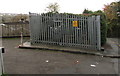
The Woods electricity substation and local transformer, Pentrepiod, Torfaen
The Western Power Distribution site is set back from the north side of Pentrepiod Road.
The electricity substation identifier is The Woods Pentrepiod S/S 532632.
The local transformer identifier is 53-2632A.
Image: © Jaggery
Taken: 6 Nov 2018
0.07 miles