IMAGES TAKEN NEAR TO
Hanbury Road, PONTYPOOL, NP4 6PH
Introduction
This page details the photographs taken nearby to Hanbury Road, NP4 6PH by members of the Geograph project.
The Geograph project started in 2005 with the aim of publishing, organising and preserving representative images for every square kilometre of Great Britain, Ireland and the Isle of Man.

There are currently over 7.5m images from over14,400 individuals and you can help contribute to the project by visiting https://www.geograph.org.uk
Image Map
Images are licensed for reuse under creativecommons.org/licenses/by-sa/2.0
Notes
- Clicking on the map will re-center to the selected point.
- The higher the marker number, the further away the image location is from the centre of the postcode.
Image Listing (217 Images Found)
Images are licensed for reuse under creativecommons.org/licenses/by-sa/2.0
Image
Details
Distance
1
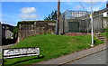
Oakdale Place electricity substation, Pontnewynydd
Accessed by steps, the Western Power Distribution electricity substation is on a small bank above Oakdale Place. Its identifier is OAKDALE PLACE PONTNEWYNYDD S/S No. 532631.
Image: © Jaggery
Taken: 1 Sep 2016
0.02 miles
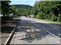
2

Bus stop opposite the Forgehammer pub, Pontnewynydd
The stop on this side of Hanbury Road is for buses towards the centre of Pontypool.
Image: © Jaggery
Taken: 1 Sep 2016
0.02 miles
3
South side of the Forgehammer, Pontnewynydd
Pub on the south side of Hanbury Road, viewed from the Estate Road side at the edge of Pontnewynydd Industrial Estate.
Image: © Jaggery
Taken: 1 Sep 2016
0.02 miles
4
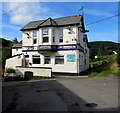
East side of the Forgehammer, Pontnewynydd
Pub on the south side of Hanbury Road, above Estate Road and Pontnewynydd Industrial Estate.
Image: © Jaggery
Taken: 1 Sep 2016
0.02 miles
5

Bilingual name sign Nightingale Terrace/Teras yr Eos, Pontnewynydd
The faded English/Welsh sign is on the left here. http://www.geograph.org.uk/photo/5100745
Image: © Jaggery
Taken: 1 Sep 2016
0.02 miles
6
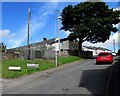
Up Oakdale Place, Pontnewynydd
Oakdale Place ascends from Hanbury Road towards Hanbury Gardens.
A Western Power Distribution electricity substation http://www.geograph.org.uk/photo/5100743 is on the left.
Image: © Jaggery
Taken: 1 Sep 2016
0.03 miles
7
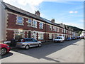
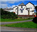
Albion Place, Hanbury Road, Pontnewynydd
Separately-named long row of houses on the south side of Hanbury Road.
Image: © Jaggery
Taken: 1 Sep 2016
0.03 miles
8
Estate Road bus stop in Pontnewynydd Industrial Estate
The yellow bilingual BUS STOP/SAFLE BWS (English/Welsh) is painted on Estate Road, the main road through the industrial estate.
Image: © Jaggery
Taken: 1 Sep 2016
0.04 miles
9
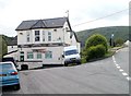
The Forgehammer, Pontnewynydd, Pontypool
Pub located between Hanbury Road (on the right) and Estate Road.
Image: © Jaggery
Taken: 26 May 2011
0.04 miles
10
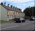
Forge Row, Estate Road, Pontnewynydd
Row of houses extending for 35 metres, opposite Pontnewynydd Industrial Estate.
Image: © Jaggery
Taken: 1 Sep 2016
0.05 miles