1
Bilingual name sign Nightingale Terrace/Teras yr Eos, Pontnewynydd
The faded English/Welsh sign is on the left here. http://www.geograph.org.uk/photo/5100745
Image: © Jaggery
Taken: 1 Sep 2016
0.02 miles
2
Chapel Terrace, Hanbury Road, Pontnewynydd
Chapel Terrace (Teras y Capel in Welsh) is a short row of houses on the south side of Hanbury Road.
Image: © Jaggery
Taken: 1 Sep 2016
0.02 miles
3
Albion Place, Hanbury Road, Pontnewynydd
Separately-named long row of houses on the south side of Hanbury Road.
Image: © Jaggery
Taken: 1 Sep 2016
0.02 miles
4
Bus stop opposite the Forgehammer pub, Pontnewynydd
The stop on this side of Hanbury Road is for buses towards the centre of Pontypool.
Image: © Jaggery
Taken: 1 Sep 2016
0.02 miles
5
Oakdale Place electricity substation, Pontnewynydd
Accessed by steps, the Western Power Distribution electricity substation is on a small bank above Oakdale Place. Its identifier is OAKDALE PLACE PONTNEWYNYDD S/S No. 532631.
Image: © Jaggery
Taken: 1 Sep 2016
0.03 miles
6
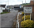
Beverstock premises, Pontypool
Premises of H.Beverstock and Son, motor and general engineers, set back from a street named Mount Pleasant.
Image: © Jaggery
Taken: 26 May 2011
0.03 miles
7
Estate Road, Pontypool
The view east from near the entrance http://www.geograph.org.uk/photo/2441115 to Pontypool Trade & Industrial Park. The path on the left ascends towards The Forgehammer pub http://www.geograph.org.uk/photo/2441111 and Hanbury Road.
Image: © Jaggery
Taken: 26 May 2011
0.03 miles
8
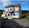
South side of the Forgehammer, Pontnewynydd
Pub on the south side of Hanbury Road, viewed from the Estate Road side at the edge of Pontnewynydd Industrial Estate.
Image: © Jaggery
Taken: 1 Sep 2016
0.03 miles
9
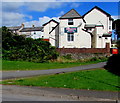
East side of the Forgehammer, Pontnewynydd
Pub on the south side of Hanbury Road, above Estate Road and Pontnewynydd Industrial Estate.
Image: © Jaggery
Taken: 1 Sep 2016
0.03 miles
10
Long row of houses, Hanbury Road, Pontnewynydd
The corner of Oakdale Place is on the left.
Image: © Jaggery
Taken: 1 Sep 2016
0.04 miles


