IMAGES TAKEN NEAR TO
Hanbury Road, PONTYPOOL, NP4 6PF
Introduction
This page details the photographs taken nearby to Hanbury Road, NP4 6PF by members of the Geograph project.
The Geograph project started in 2005 with the aim of publishing, organising and preserving representative images for every square kilometre of Great Britain, Ireland and the Isle of Man.

There are currently over 7.5m images from over14,400 individuals and you can help contribute to the project by visiting https://www.geograph.org.uk
Image Map
Images are licensed for reuse under creativecommons.org/licenses/by-sa/2.0
Notes
- Clicking on the map will re-center to the selected point.
- The higher the marker number, the further away the image location is from the centre of the postcode.
Image Listing (237 Images Found)
Images are licensed for reuse under creativecommons.org/licenses/by-sa/2.0
Image
Details
Distance
1
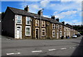
Long row of houses, Hanbury Road, Pontnewynydd
The corner of Oakdale Place is on the left.
Image: © Jaggery
Taken: 1 Sep 2016
0.02 miles
2
Wesley Funeral Home, Pontypool
Located at 87 Hanbury Road.
Image: © Jaggery
Taken: 26 May 2011
0.03 miles
3
Balloons & Bouquets, Pontnewynydd, Pontypool
The single-storey building on Hanbury Road is the premises of Balloons & Bouquets Flower Barn, florists. Its neighbour on the left is Moments, fancy dress hire.
Image: © Jaggery
Taken: 26 May 2011
0.03 miles
4
Chapel Terrace, Hanbury Road, Pontnewynydd
Chapel Terrace (Teras y Capel in Welsh) is a short row of houses on the south side of Hanbury Road.
Image: © Jaggery
Taken: 1 Sep 2016
0.04 miles
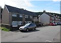
5
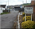
Beverstock premises, Pontypool
Premises of H.Beverstock and Son, motor and general engineers, set back from a street named Mount Pleasant.
Image: © Jaggery
Taken: 26 May 2011
0.04 miles
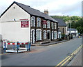
6
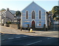
Pontnewynydd Methodist Church
Blue-painted church on the corner of Hanbury Road and Pentrepiod Road, viewed across Osborne Road (A4043). The inscription on the roundel above the central window is WESLEYAN CHAPEL 1849.
Image: © Jaggery
Taken: 25 Oct 2010
0.06 miles
7
Pontnewynydd Community Centre, Pontypool
Located on Pentre-piod Road.
Image: © Jaggery
Taken: 26 May 2011
0.06 miles
8
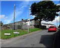
Up Oakdale Place, Pontnewynydd
Oakdale Place ascends from Hanbury Road towards Hanbury Gardens.
A Western Power Distribution electricity substation http://www.geograph.org.uk/photo/5100743 is on the left.
Image: © Jaggery
Taken: 1 Sep 2016
0.06 miles
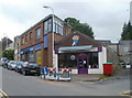
9
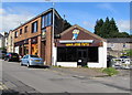
Quick Stop Party shop in Pontnewynydd
Balloon decorators and party ware shop viewed across Hanbury Road.
Image: © Jaggery
Taken: 1 Sep 2016
0.06 miles
10
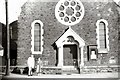
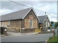
Merchants Hill Baptist Church, Pontnewynydd
Located on the corner of Osborne Road and Merchants Hill. The inscription above the doorway is BAPTIST CHAPEL 1888.
Image: © Gerald England
Taken: Unknown
0.06 miles