1
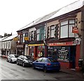
Puddle premises and van, Pontypool
Viewed across Osborne Road. A.C.Puddle & Co Ltd's business is central heating, fires, fireplaces and stoves. The building looks like it may have been a church or chapel.
Image: © Jaggery
Taken: 2 Jan 2014
0.02 miles
2
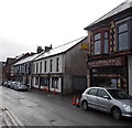
New Yummies, Pontypool
Information on the window shows that the Osborne Road takeaway is open 7 days a week, including Bank Holidays. Friday and Saturday opening times are shown as 3pm to 2am.
Image: © Jaggery
Taken: 2 Jan 2014
0.02 miles
3
Riverside Court, Pontypool
Managed by Torfaen County Borough Council, Riverside Court has 22 single-bedroom flats (housing with support). There is a resident management staff and community alarm service. Accommodation is rented.
Riverside Court was built in 1973, on the east bank of the Afon Lwyd river.
Image: © Jaggery
Taken: 4 May 2011
0.03 miles
4
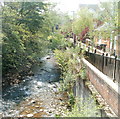
Afon Lwyd flows alongside Afon Lwyd Close, Pontypool
Viewed from the corner of the main road, named Riverside.
Image: © Jaggery
Taken: 4 May 2011
0.03 miles
5
Bryan Watkins & Son DiY Centre, Pontypool
The shop front is on both sides of the gap which leads to the shop entrance and yard of the Osborne Road DiY Centre and Builders' Merchants. The nameboard on the right shows that the business was established in 1960.
Image: © Jaggery
Taken: 2 Jan 2014
0.04 miles
6
Old railway signals at Pontypool ? 1967
The signals dated from the days of the former Monmouthshire Railway, never replaced by either the Great Western Railway or British Railways. Behind, the bridge carrying George Street across the railway, and the Fountain Inn. All the foreground has disappeared under the A4043, https://www.geograph.org.uk/photo/3790116 , constructed along the line of the railway.
Image: © Alan Murray-Rust
Taken: 30 Dec 1967
0.04 miles
7
A4043 looking north
Image: © Colin Pyle
Taken: 17 Dec 2013
0.04 miles
8
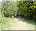
Track into woods from Riverside, Pontypool
Boulders block vehicular access to a track along the eastern bank of the Afon Lwyd, into woodland. Viewed from the edge of a road named Riverside.
Image: © Jaggery
Taken: 4 May 2011
0.04 miles
9
Afon Lwyd Close, Pontypool
Modern housing viewed across the main road, Riverside.
Image: © Jaggery
Taken: 4 May 2011
0.04 miles
10
Afon Lwyd upstream from Riverside, Pontypool
The Afon Lwyd flows towards the bridge carrying a main road, Riverside, over the river.
Image: © Jaggery
Taken: 4 May 2011
0.04 miles


